
Archive

Digital Library of Indian Maps Soon to be Live: NATMO
The National Atlas and Thematic Mapping Organisation (NATMO) is developing a digital library of Indian maps and will make availability of e-maps to the citizens within a year. NATMO prepare atlases
Master Geomatica from the comfort of your Home! 2015 Training Sessions on Now!
PCI Geomatics is the world leader in geo-imaging products and solutions. PCI Geomatics has set the standard in remote sensing and image processing tools offering customized solutions to the geomatics
Geological Survey of Israel Chooses SuperGIS Desktop
Supergeo Technologies Inc. announces that the Geological Survey of Israel utilizes SuperGIS Desktop and extensions such as Spatial Analyst, Spatial Statistics Analyst and 3D Analyst, to enhance the efficiency of
DigitalGlobe Expands Partnership With Orbital Insight
Sep. 10, 2015 – Today we are excited to announce an expansion of our partnership with Orbital Insight, a geospatial analysis company that tracks socioeconomic trends at global, regional, and

Webinar on Transition of ENVI Analytics from Desktop to Web
Webinar on Transition of ENVI Analytics from Desktop to Web Tuesday, September 15, 2015 1:30 pm Singapore Time (Singapore, GMT+08:00) Geospatial imagery is used more and more across industries because

Specim, A Global Leader In Hyperspectral Imaging, Granted 5.3 M€ Growth Financing
/INS. SPECIM, Spectral Imaging Oy Ltd., a pioneer and global leader in hyperspectral imaging instruments and systems, has received 5,3 M€ of financing to ensure its growth. The financing package

Join the Esri Social Services App Challenge Today
Esri and the International City/County Management Association (ICMA) have partnered to connect civic-minded coders and local government officials to help them create next-generation apps. Enter the Esri and ICMA Social
NSF and NGA Support Development of New Topographic Maps of the Arctic
The National Science Foundation (NSF), in partnership with the National Geospatial-Intelligence Agency (NGA), is supporting development of high-resolution topographic maps of the Arctic that for the first time will provide
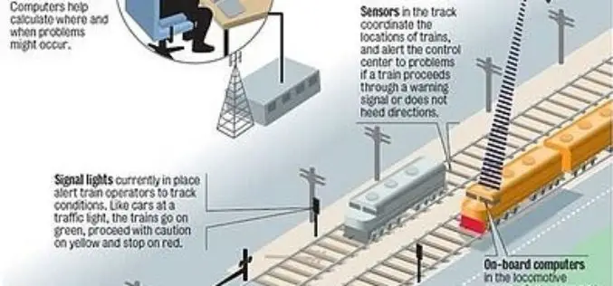
Indian Railways to Tie Up With ISRO for Enhanced Safety Using GPS Aided System (GAGAN)
Indian Railways will join hands with ISRO to get online satellite images for improving safety and enhancing efficiency. “We will undertake a massive exercise of GIS mapping of the entire
Remote Sensing Applications Webinar- NSW, RSPC
SSSI NSW are proud to present a webinar on “Remote Sensing Applications”. This webinar will cover interesting applications for satellite imagery. Dr Andrew Robson, from the University of New England,
