
Archive
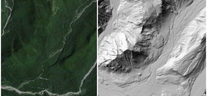
OpenTopography Releases Raster Datasets for California, Colorado, New Hampshire and Washington
Recently OpenTopography has to announce the release of seven new raster datasets. These datasets are available for areas in California, Colorado, New Hampshire and Washington. All datasets were collected between 2010 and 2012.
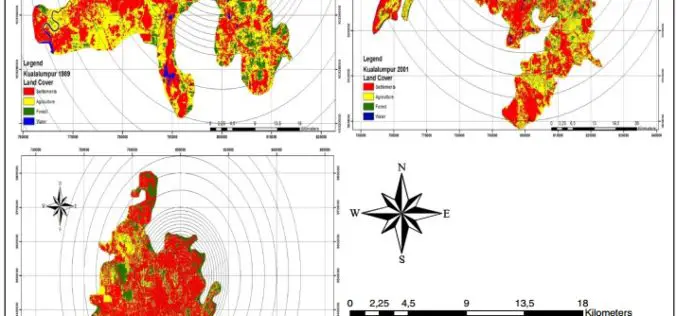
Monitoring and Modeling of Urban Growth Through Remote Sensing and GIS
Monitoring and Modeling of Urban Sprawl Through Remote Sensing and GIS in Kuala Lumpur, Malaysia – Mukesh Singh Boori, Maik Netzband , Komal Choudhary and Vít Voženílek Kuala Lumpur is
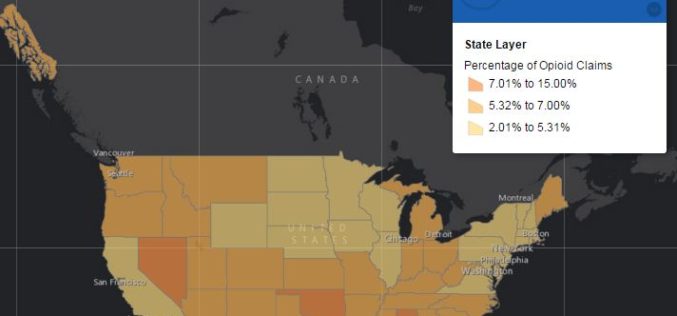
Centers for Medicare & Medicaid Services Has Launched Drug Mapping Tool Available
Interactive online drug mapping tool allows public to search Medicare Part D opioid prescription claims data at the state, county, and ZIP code levels. The Centers for Medicare & Medicaid

OS Maps Play a Role in the New UK Passports
The latest UK passport design was released yesterday and we’re extremely pleased to see a range of mapping from OS OpenData across the pages. Launched at Shakespeare’s Globe in London, the

Remote Sensing Technology to Monitor Crop Residue Management
Taking note of non-implementation of two advisories issued to curb burning of crop residues which was leading to smog in NCR region including Delhi, the Centre today asked four states
PrecisionHawk Partners With Genera Energy to Build Aerial Analysis Tools for Biomass Crops
The automated algorithms will assess crop health and productivity using aerial farm imagery collected by satellites and drones. PrecisionHawk and Genera Energy have partnered to develop new analysis algorithms specific to improving the
Make Your Data Persuasive With SuperGIS Desktop
With constant development in information technologies, people often worry about getting too much information instead of getting too little. The ability to sum up information into a simple but clear

OGC and ASPRS to Collaborate On Geospatial Standards; Invite Participation in Point Cloud Work
The Open Geospatial Consortium (OGC) and the American Society for Photogrammetry and Remote Sensing (ASPRS) have agreed to work together more closely in the application and promotion of standards and best practices for the

Esri Collaborates with Microsoft to Incorporate Location Services and Spatial Analytics
Internet of Things Innovation Benefits Enterprise Organizations across Industries and Verticals The Internet of Things (IoT) inspires new ways of thinking about how we work with and share information. And
Join Free Training on Bhuvan – Gateway to Geospatial World
Training on Bhuvan – Gateway to Geospatial World December 08 – 09, 2015 Bhuvan, (lit: Earth), is a software application which allows users to explore a 2D/3D representation of the
