
Archive
PhD candidate on Fingerprinting Remote Sensing Based Vegetation Types for Application in Global Vegetation Model
Leiden University (founded in 1575) is one of Europe’s leading international research-intensive universities. This prominent position gives our graduates an advantage when applying for positions both within and outside the
Ebook on Remote Sensing Applications
National Remote Sensing Center (NRSC) focusing on promotion of Remote Sensing Technology and Applications among users in India. The Centre is responsible for remote sensing satellite data acquisition and processing, data

Webinar: Raster Processing In Global Mapper
Raster Processing In Global Mapper November 19, 2015 No Registration Required In many GIS processes and procedures, raster data serves as a static base map or reference layer upon which

Seminar on Geodesy, Navigation and Positioning
Aalto University is a new university with over a century of experience. Created from a high-profile merger between three leading universities in Finland – the Helsinki School of Economics, Helsinki
PhD Candidate Unmanned Aerial Vehicles (UAVs) for Cadastral Mapping
The University of Twente. We stand for life sciences and technology. High tech and human touch. Education and research that matter. New technology which drives change, innovation and progress in
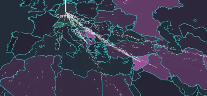
Mapping to Visualize the European Refugee Crisis
Europe is experiencing the biggest refugee crisis since World War II. The map shows the flow of asylum seekers to European countries over time. The data from the UN refugee agency (UNHCR) publishes monthly
