
Archive

Geographic Calculator 2016 Now Available with Significant Upgrades in Design and Performance
Hallowell, Maine – December 15, 2015 – Blue Marble Geographics (bluemarblegeo.com) is pleased to announce the release of the Geographic Calculator 2016. This major upgrade to the industry’s preeminent geodetic

European Space Imaging Wins Additional Supply Contract for the European Commission
Munich, 16/12/15 – European Space Imaging announced today that the company has signed an additional multi-year framework supply contract with the European Commission for the provision of very high-resolution (VHR)

The “Radar Vision” Goes On – Two More Sentinel-1 Satellites
– Airbus Defence and Space signs €143M contract with Thales Alenia Space – New Sentinel instruments ensure services for Copernicus beyond 2029 Airbus Defence and Space, the world’s second-largest space

India Successfully Launched All the 6 Singapore Satellites
India has successfully launched all the 6 Singapore Satellites into their orbits using Polar Satellite Launch Vehicle (PSLV-C29). PSLV-C29 was launched from the First Launch Pad at Satish Dhawan Space Centre
Boundless Participates in Release of GeoNode 2.4
Boundless Hosts Code Sprint in New Orleans and Announces Important Functionality in GeoNode 2.4 Boundless, the leading provider of open source geospatial software and services, today highlighted the latest release

OGC Announces Standard That Makes Complex Environmental Data Easier To Use in GIS
The membership of the Open Geospatial Consortium (OGC) has approved the OGC CF-netCDF 3.0 encoding using GML Coverage Application Schema, an extension to the OGC CF-netCDF 3.0 encoding standard. The

15 Smart City Proposals from 7 States Received By UD Ministry; Rajasthan First to Do So
Investment of Rs.6,457 cr proposed in 4 smart cities in Rajasthan over 5 years; greenfield city near Kota 1.81 crore citizens participated in preparation of smart city proposals; 25 lakhs

New Leica ULTRA Locator: Best Accuracy Results in Faster, More Confident Work
Outstanding performance with operational ease and flexibility help users attain the highest accuracy to avoid costly mistakes, such as cutting utility lines or delaying project schedules during excavation work. By

FAA Announces Small UAS Registration Rule
UAS Registration Begins on December 21, 2015, First 30 Days are Free WASHINGTON – The U.S. Department of Transportation’s Federal Aviation Administration (FAA) today announced a streamlined and user-friendly web-based
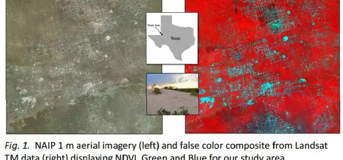
Utilizing Patch Metrics to Improve Classification of Remote Sensing Imagery
Classified remote sensing imagery is used to inform management of various natural resources, though achieving accurate results is a persistent challenge. In particular, some land cover types that are functionally
