
Archive

Ordnance Survey Acquire Shareholding in Dennis Maps
Ordnance Survey (OS) and Dennis Maps have signed an agreement for Britain’s mapping agency to acquire a 25% The new partnership builds on the relationship between the two organisations which commenced

National Geospatial Policy to Standardize GIS Assets for the Entire Country
According to recent news by The New Indian Express, inaugurating the Winter School on ‘Geospatial Technologies-Application to Science and Engineering Research’, organised by the department of Environmental Studies at GITAM

Indian Government Plans to Track Illegal Mining Using Space Technology
NEW DELHI: The government has finalised its plans to track illegal mining in the country using space technology and satellite imagery in partnership with Indian Space Research Organisation (ISRO). This
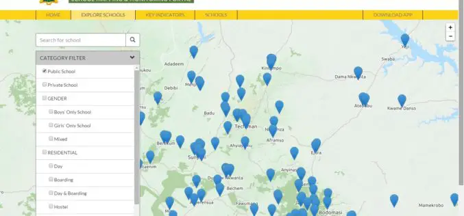
Ghana: Education Ministry Launches School Mapping Portal
The School Mapping and Monitoring system, a programme under the Secondary Education Improvement Project (SEIP), has been launched under the host name www.ghanaschoolsinfo.org. Speaking at the launch, the Minister for
Contour Mapping for Flood Free Mumbai
According to recent news by the Hindustan Times, Maharastra Chief Minister Devendra Fadnavis has informed in State Assembly that contour mapping will be made mandatory for builders who seek permission
Geospatial Research Program to Collaborate on Five New Projects in 2016
FAYETTEVILLE, Ark. – The Spatial Archaeometry Research Collaborations Program, a National Science Foundation-funded initiative at the Center for Advanced Spatial Technologies at the University of Arkansas, will collaborate on five

Esri and NASA Collaborate to Advance Cloud Access to Imagery
Esri Opens LERC to the Geospatial Community Redlands, California—Esri and NASA are collaborating to improve access to imagery and raster data stored in the cloud using a combination of two
The First Remote Sensing Atlas to be Launched in SA
SANSA has produced the first remote sensing atlas for the country. The atlas will be launched in 2016. The atlas has been developed to cater for a wide range of
Unfettered Display of Geospatial Data Pose National Security
It is essential to come up with legislation for the dissemination of images and geospatial data in the public domain before according permission to service providers such as Google as

iSTAR Panoramic Camera to Support Digital Preservation of At-Risk Heritage Sites in Syria, the Middle East
Speed of capture, image quality and ease-of-use identified as key product attributes for sensitive mission Edinburgh, UK – December 17, 2015 – NCTech, the developer of reality imaging systems, today
