
Posts From GIS Resources
Global Marketing Insights to Speak on Big Data Geospatial Analytics Platform at “Small Satellites Big Data Conference”
Cleveland, OH August 3, 2017 – Global Marketing Insights Inc., a pioneer in geospatial business intelligence and geospatial market research, will assist in demonstrating the big data processing capabilities of global-scale machine

Boeing and JAXA to Flight-test Technology to Improve Safety
SEATTLE, Aug. 2, 2017 /PRNewswire/ — Boeing [NYSE: BA] and the Japan Aerospace Exploration Agency (JAXA) will flight-test Long-range Light Detection and Ranging (LIDAR) technology next year. This remote-sensing technology could help commercial
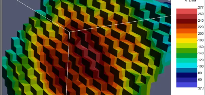
PDF3D Release PV+ 5.4 Visualization & Publishing Update
PDF3D release PV+ version 5.4, extending the ParaView visualization application with additional formats, filters and 3D PDF generation. PDF3D, leaders in 3D PDF conversion technology, have today announced the latest
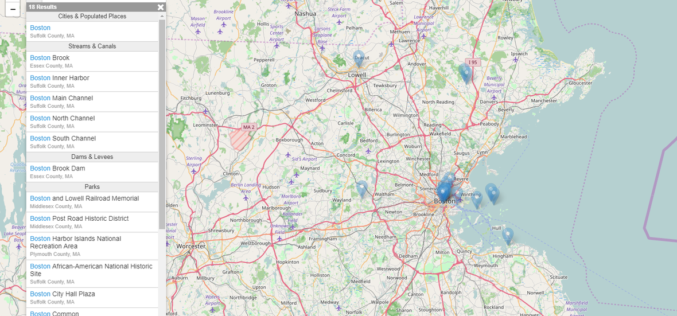
USGS Releases New JavaScript Library to Create Location Search Widgets for Web Applications
The U.S. Geological Survey Search API is a custom JavaScript library useful for creating a location search widget in a webpage, typically in conjunction with a web map. The widget connects to

Orbit GT Updates 3D Mapping Cloud With Oblique Imagery Support
“After support for Mobile Mapping and UAS Mapping content, we now proudly announce the support for Oblique Imagery and Aerial Point Clouds. From now on, anyone owning Oblique data can

FAA Administrator Michael P. Huerta to Deliver Grand Opening Keynote Address at InterDrone
Heads stellar lineup of keynotes at commercial drone industry’s largest dedicated event MELVILLE, N.Y., July 31, 2017 — BZ Media LLC today announced that Michael P. Huerta, Administrator of the

Icaros and TeAx Announce an Integrated Drone Mapping Solution for Radiometric ThermalCapture (FLIR core) Sensors
FAIRFAX, Virginia, USA / WILNSDORF, Germany, 26 July 2017 – Icaros Inc., a leading provider of aerial imaging software, is pleased to announce that version 5.1 of OneButton™ Standard and Professional

MicaSense Atlas is Now Integrated with Pix4D Desktop Software
This partnership is designed to offer MicaSense customers the power of desktop processing, as well as the flexibility of MicaSense Atlas. “Our customers value Atlas as an analytics and collaboration
USACE Mobile District Signs WMR-532 to $46M Coastal Mapping Contract
WMR-532, the joint venture of Woolpert and Optimal Geo, will provide bathymetric and topographic lidar and imagery in support of JALBTCX task orders around the world. DECATUR, Ala. (July 26,

OGC is Calling for Sponsors for an Innovative Interoperability Initiative, Testbed 14
Thursday, 27 July 2017 – The Open Geospatial Consortium (OGC®) has issued a call for sponsors for an innovative interoperability initiative, Testbed 14. The OGC Innovation Program provides a venue
