
Software
Global Mapper 18.2 Released with New 3D Digitizing Functionality and Support for Connecting to Amazon Web Services
Hallowell, Maine – May 30, 2017 – Blue Marble Geographics (www.bluemarblegeo.com) is pleased to announce the immediate availability of Global Mapper version 18.2. This latest upgrade to the version 18
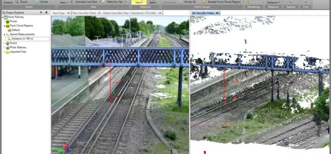
Trimble Business Center v3.90 Now Available
Trimble Business Center provides users with the capability to efficiently edit, process, and adjust geospatial data and create deliverables with confidence. The New features/updates included in TBC v3.90: Create, edit,
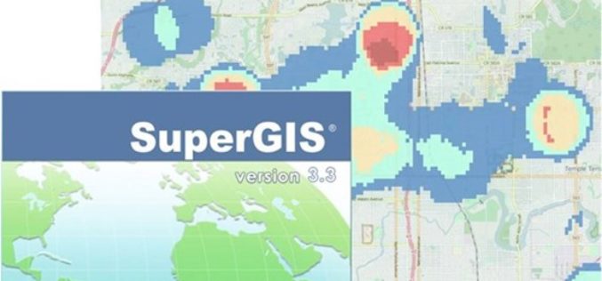
Supergeo Releases the Latest Update of SuperGIS Desktop 3.3
Developed by one of worldwide leading providers in GIS software- Supergeo, SuperGIS Desktop is a practical, multifunctional, and affordable GIS solution designed for professionals in various industries such as urban

Enjoying the High-Accuracy Positioning with the Latest SuperPad 10
The first stable version of SuperPad 10 has been released for over one and a half months. In the first release, SuperPad 10 not only already equips with numerous practical

Icaros Releases Version 5.0 of OneButton™ Drone Image Processing Software
Icaros Releases Version 5.0 of OneButton™ Drone Image Processing Software Free 30-Day Trial FAIRFAX, Virginia, USA, 15 May 2017 – Icaros Inc., a leading provider of aerial imaging software, is pleased

Global Mapper Mobile Now Available for Android Devices
Blue Marble Geographics is pleased to announce the immediate availability of a beta release of the Android version of its Global Mapper Mobile app. Mirroring the capabilities of the iOS
CARTO Delivers Most Advanced Offline Maps with New Mobile SDK for Android & IoS
Users can develop custom mobile apps with native offline mapping, location data services, and the analytical power of location intelligence New York, New York – May 09, 2017 – CARTO, the

PrecisionHawk Launches Free PrecisionMapper Software for Drone Mapping
Now drone operators can stitch an unlimited number of photos, create maps without resolution limits and run algorithms to analyze their data for free PrecisionHawk, a leading commercial drone and

TerraGo Edge 4.0 Re-Imagines the User Experience, Adds New Mobile Features and Expands ESRI® ArcGIS® Integration Options
Using a customer-driven, agile feedback loop, TerraGo Edge undergoes a complete redesign, improves every aspect of the user experience to help get work done faster, easier and more efficiently than
Blue Marble Releases Geographic Calculator 2017 with New Quality Control Tool for Seismic Survey Data
Hallowell, Maine – April 18, 2017 – Blue Marble Geographics (bluemarblegeo.com) is pleased to announce the immediate availability of Geographic Calculator 2017. This major version release introduces a new job
