
Software
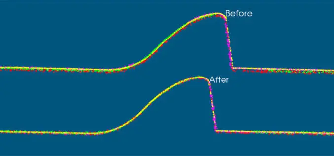
VRMesh V9.5 Available with New Advanced Features for LiDAR Strip Adjustment
Oct. 12th, 2017 – VirtualGrid is pleased to announce the availability of VRMesh v9.5, the latest version of its powerful 3D point cloud and mesh processing software. This new release

PDF3D Work With Forensics to Bring 3D PDF into the Court Room
3D PDF conversion software leaders, PDF3D, have today released a new eBook that will help forensic investigators and engineers improve presentation of evidence and 3D reconstructions in court. London, October

SimActive Announce the Release of Correlator3D™ version 7.0
SimActive Inc., is pleased to announce the release of Correlator3D™ version 7.0, with complete redesign of its 3D generation engine enabling substantial quality and speed improvements. Version 7.0 also includes

Global Mapper v.19 Now Available with New Attribute Table Editor and Interactive Hillshade Rendering
Blue Marble Geographics is pleased to announce the release of Global Mapper version 19. With numerous functional improvements and performance enhancements throughout the application, the version 19 release is further

PCI Geomatics Releases Geomatica 2017, Service Pack 1
MARKHAM, Ontario, Canada, September 12, 2017 – PCI Geomatics, a world leading developer of remote sensing and photogrammetric software and systems, announced today the release of Service Pack 1 for
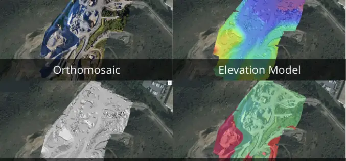
3 New Elevation Viewers, Now in Site Scan
August 9, 2017 – One of the most common uses for Site Scan is performing topographic surveys: you can use a drone to survey your site faster, safer, and more cost-effectively,

TerraGo Mobile Apps Add New Advanced Mapping Features and Laser Range Finder Integration
TerraGo Mobile Apps Add New Advanced Mapping Features and Laser Range Finder Integration TerraGo Edge 4.1 and any app created with the TerraGo Magic zero-code app platform includes enhanced mapping and surveying features

Embarcadero and TatukGIS Announce New Tool for RAD Studio
Latest geographic information system development kit allows RAD Studio developers to create desktop, client-server and mobile GIS apps AUSTIN, Texas–(BUSINESS WIRE)–Embarcadero Technologies (a division of IDERA) and TatukGIS today announced that TatukGIS has released
USGS Releases New JavaScript Library to Create Location Search Widgets for Web Applications
The U.S. Geological Survey Search API is a custom JavaScript library useful for creating a location search widget in a webpage, typically in conjunction with a web map. The widget connects to

Trimble Introduces New Android Application for Field Surveying and Data Collection
Easy-to-Use Trimble Penmap for Android Simplifies Field Work SUNNYVALE, Calif., July 26, 2017—Trimble (NASDAQ: TRMB) introduced today Trimble® Penmap® for Android™, a cloud-connected application for field surveying and high-accuracy Geographic
