As the demand for highly accurate positioning systems grows, Geoscience Australia has launched Ginan, an open-source real-time positioning correction service. Developed as part of the Positioning Australia program, Ginan offers centimetre-level accuracy for various global navigation satellite system (GNSS) applications. Its open-source nature allows for customization and innovation, providing vast opportunities for research, industry, and academia.
Ginan – The Positioning Australia Program
Ginan is part of the Positioning Australia initiative, funded by the Australian Government and led by Geoscience Australia. The program aims to deliver accurate and reliable positioning services across Australia, supporting a wide range of industries from agriculture to construction. Ginan plays a pivotal role in this effort by enhancing GNSS signals with real-time positioning correction data, making it a crucial tool for high-precision tasks.
This program includes collaboration with international academic institutions and companies like FrontierSI, ensuring that Australia remains at the forefront of GNSS technology. The combination of government support and open-source accessibility makes Ginan a dynamic force in advancing global navigation systems through its open-source real-time positioning correction service.
How Ginan Works
Ginan operates as an advanced GNSS processing engine that utilizes models of Earth’s gravity (including Earth tides) and atmospheric conditions to produce corrections for possible errors. This process significantly reduces the uncertainty associated with the parameter being analyzed.
Ginan leverages Precise Point Positioning (PPP) technology, utilizing satellite signals and advanced algorithms to generate correction data that drastically improves positioning accuracy.
By using models such as State Space Representation (SSR), Ginan minimizes potential errors caused by atmospheric interference and satellite orbits. In the traditional GNSS positioning process, minor errors can limit the user’s position accuracy to within a few meters. The SSR methodology helps correct these small errors, enhancing GNSS observations. With these corrections, Ginan is capable of achieving Precise Point Positioning (PPP) accuracy ranging from decimeter to millimetre levels, depending on the quality of the PPP corrections applied.
Also Read – Free GPS Online Post Processing Services
At the core of Ginan is a Kalman filter processing engine. This algorithm processes data received from GNSS satellites and other supporting metadata to estimate unknown variables, such as the user’s precise location. The Kalman filter in Ginan works with raw, undifferentiated GNSS data and can estimate all GNSS observation model states, either in their uncombined form or using ionosphere-free combinations of GNSS observations.
The software’s capabilities include handling raw GNSS observation data from multiple satellite constellations, such as GPS, GLONASS, Galileo, and BeiDou, and filtering out unwanted signal noise to provide reliable positioning outputs. Ginan’s processing method, called Undifferenced/Uncombined (UDUC), enhances accuracy by estimating and removing errors that typically affect GNSS signals. This method is key to Ginan’s ability to provide real-time corrections with an impressive level of accuracy.
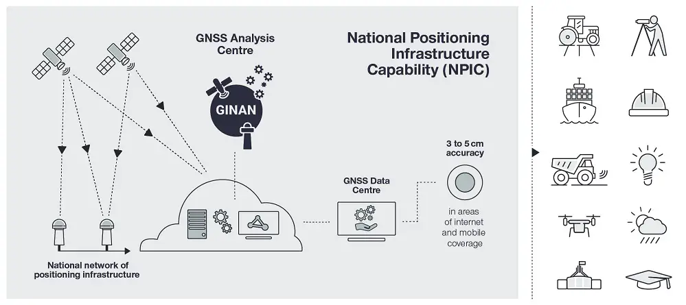
Image Credit: Geoscience Australia
Applications of Ginan – Open-Source Real-Time Positioning
Ginan’s flexibility and precision enable its use across various sectors:
- Agriculture: Farmers can use real-time correction data to optimize precision farming, improving crop yields by accurately guiding equipment.
- Transportation: Autonomous vehicles, both on land and in the air, benefit from Ginan’s open-source real-time positioning correction, ensuring safe navigation.
- Geoscience: By maintaining and enhancing Australia’s geodetic datums, Ginan contributes to accurate earthquake and crustal movement monitoring, crucial for disaster preparedness.
- Mobile Devices: Ginan’s data can be integrated into smartphones and tablets, delivering improved accuracy for consumer applications like navigation and geolocation services.
The system’s ability to combine multi-GNSS data from various constellations ensures it can be widely applied, from monitoring atmospheric conditions to mapping land movements.
Also Read – Enhancing Tectonic Studies with Machine Learning For Crustal Velocity Prediction
Why Open Source?
One of the standout features of Ginan is its open-source approach. By making the tools freely available, Geoscience Australia encourages innovation. Researchers, educators, and commercial entities can access the software to develop new technologies and services. This open-source real-time positioning correction model lowers barriers to experimentation, helping drive advancements in geospatial technology.
For universities, this also serves as a valuable educational tool. Students can analyze the software’s algorithms, gaining hands-on experience with GNSS processing methods. Furthermore, Ginan supports commercial organizations by providing the foundation for creating marketable positioning solutions, potentially unlocking new economic opportunities.
Moreover, the software’s interoperability allows it to be integrated into various applications across industries. For example, it can be utilized in agriculture, surveying, autonomous vehicles, Internet of Things (IoT) devices, and space situational awareness. By providing an open-source solution, Ginan reduces barriers to entry for those looking to leverage precise positioning technology, fostering a thriving ecosystem of GNSS-based innovations.
Conclusion
In the world of GNSS technology, Ginan stands out as a leading open-source real-time positioning correction service. Its ability to provide centimetre-level accuracy across a wide array of industries—along with its open-source accessibility—makes it a game-changer in geospatial positioning. Whether in agriculture, autonomous transport, or scientific research, Ginan offers a reliable solution for precise positioning needs.
For those interested in exploring Ginan further, access to the software and its continuous updates is available on Geoscience Australia’s GitHub page. This toolkit is customizable, allowing developers and researchers to modify certain elements to meet specific needs, from academic research to commercial applications.
As this technology continues to evolve, its potential applications are bound to grow, pushing the limits of GNSS accuracy and innovation.
References:
- Geoscience Australia. “Ginan – Positioning Australia’s Real-Time Correction Service.” Geoscience Australia.
- Positioning Australia. “Ginan’s Role in Improving GNSS Accuracy.” Positioning Australia.