Hyderabad Metropolitan Development Authority Plan to Integrate Previous Five Master plans
Hyderabad, India – According to recent news reported by The Hindu, Hyderabad Metropolitan Development Authority (HMDA) is planning to integrate previous five master plans into a single Metropolitan Development Plan (MDP) of 2031.
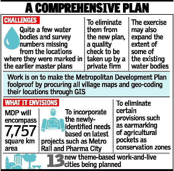
To eliminate old data and wrong data from the newly-proposed master plan, a quality check would be undertaken on the ground level by a private consultant deployed by HMDA, informed R. Nageshwar Rao, a Planning Officer from the urban development body, while addressing a consultative meeting with the stakeholders and civil society organisations here on Saturday. The meet was organised by the Forum for a Better Hyderabad.
Peculiar challenges stare at Hyderabad Metropolitan Development Authority .
Credit: The Hindu
The quality check may also expand the extent of some of the existing water bodies, as happened in the case of Raviral Tank. The tank, shown to occupy mere 400 acres in the previous plans, is now identified to have spread over double the extent, Mr. Rao informed.
Rigorous work is on to make the MDP foolproof by procuring all village maps and geo-coding their locations through geographical information system (GIS) before correcting the anomalies, Mr. Rao said, after a presentation by a representative from the consultant LEA Associates.
It will incorporate the newly-identified needs based on latest projects such as Metro Rail and Pharma City, while also eliminating certain provisions such as earmarking of the agricultural pockets as conservation zones, which, he said, could prove to be redundant in view of the changed priorities.
Thirteen new theme-based work-and-live cities are being planned along the Outer Ring Road as the transit-oriented growth centres, akin to the satellite townships. The integration process which had begun in July is expected to be completed by December this year.