New Tool for Understanding the Risk of Humanitarian Crises and Disasters
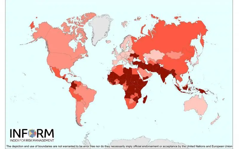
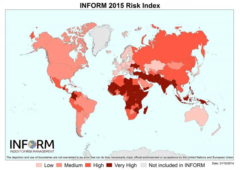
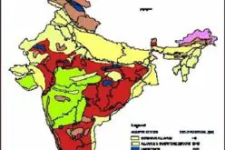
INFORM map shows risk of humanitarian crises and disasters across the globe.
© EU
The first global open-source risk assessment tool for humanitarian crises and disasters was launched today.INFORM (Index for Risk Management) is designed to support decisions about prevention, preparedness and response, helping humanitarian actors to align their actions in order to reduce crisis and disaster risk and to build resilience. It is the result of joint efforts of a partnership of international organisations and governments, including the JRC.
Understanding why and where humanitarian disasters are likely to occur is a fundamental step in saving lives and promoting sustainable development. Most crises can be predicted to some extent, but while they cannot always be prevented, the suffering they cause can often be greatly reduced.
INFORM is a risk index that identifies where crises requiring international assistance may occur and analyses that risk so it can be better managed by everyone. It can be used to prioritise between countries by risks, to decide how to prepare and reduce risks, and to monitor risk trends. INFORM can also be used to measure risks at sub-national level. The INFORM partners are working with regional and national counterparts to develop region- and country-specific versions of INFORM.
INFORM simplifies a large quantity of information about risks into a simple risk profile for each country – for a total of 191 countries. It combines around 50 different indicators that measure natural and human hazards (events that could occur), vulnerability (the susceptibility of communities to those hazards) and capacity (resources available that can alleviate the impact). The results and data are freely available.
INFORM has been created to solve a common problem among humanitarian actors – how to prioritise limited resources to mitigate and prepare for crises. It is the result of collaboration between the Inter-Agency Standing Committee Task Team for Preparedness and Resilience and the European Commission, which brought together a large group of partners for the development phase.
Working in close collaboration with the Directorate-General for Humanitarian Aid and Civil Protection (ECHO), the JRC has been the driver of the initiative. With its expertise in natural disasters, risk management, geospatial information and statistics, it has led the development of the science-based composite indicator. The JRC also developed the dedicated IT tools to collect, process and publish the statistical data used by INFORM, and hosts the website.
The INFORM partners are already using the system to help with the decision-making and they encourage a wider use by the risk management community aiming to be more effective at managing risk and building resilience together.
Source: European Commission