Researchers Integrate Optical and Radar Satellite Data for Conflict Damage Detection in Ukraine
A new peer-reviewed study published in Nature Scientific Reports has demonstrated how combining optical satellite imagery with Synthetic Aperture Radar (SAR) remote sensing data can improve the accuracy of conflict-related building damage detection in Ukraine. The research, released in March 2026, advances the field of satellite remote sensing for humanitarian damage assessment, providing a scalable framework that could be applied wherever ground access is restricted.
Background
The ongoing conflict in Ukraine has created an urgent need for systematic, large-area damage assessment without requiring field access to active or recently contested areas. Remote sensing-based damage mapping has emerged as the primary tool for this purpose, combining freely available satellite data with geospatial analysis to identify structural damage to buildings and critical infrastructure. Previous studies have used single-sensor approaches — either optical imagery from platforms such as Sentinel-2, Planet, or Maxar’s WorldView-3, or SAR data from Sentinel-1 — but each has limitations. Optical sensors cannot penetrate cloud cover and are constrained by daylight availability, while SAR sensors offer all-weather, day-and-night capability but produce imagery that is harder to interpret and more sensitive to surface texture change than to categorical damage types.
Also Read – Effective usage of SAR data to monitor Oilfield Ground Displacement
Technology and Methodology: Integrated Optical and Radar Remote Sensing for Damage Detection in Ukraine
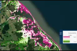
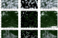
The study fuses multispectral optical imagery and C-band SAR backscatter data in a change detection framework operating at the pixel and object scales. Pre-conflict and post-conflict image pairs were co-registered and orthorectified to a common spatial reference, with topographic corrections applied to the SAR data using Shuttle Radar Topography Mission (SRTM) Digital Elevation Models
Change metrics were computed independently for optical channels — including spectral indices sensitive to rubble, bare ground, and vegetation loss — and for SAR coherence and amplitude difference images. SAR coherence is particularly sensitive to building collapse: intact structures maintain consistent radar reflections between acquisitions, while destroyed buildings lose surface coherence as roof geometry changes. The two information streams were then fused using a machine learning classifier trained on reference damage labels derived from very high resolution (VHR) commercial satellite imagery (sub-metric resolution). The combined optical-SAR approach outperformed either single-sensor method in producer’s and user’s accuracy assessments, particularly for detecting moderate damage that neither sensor alone resolved reliably.
Implementation and Study Area
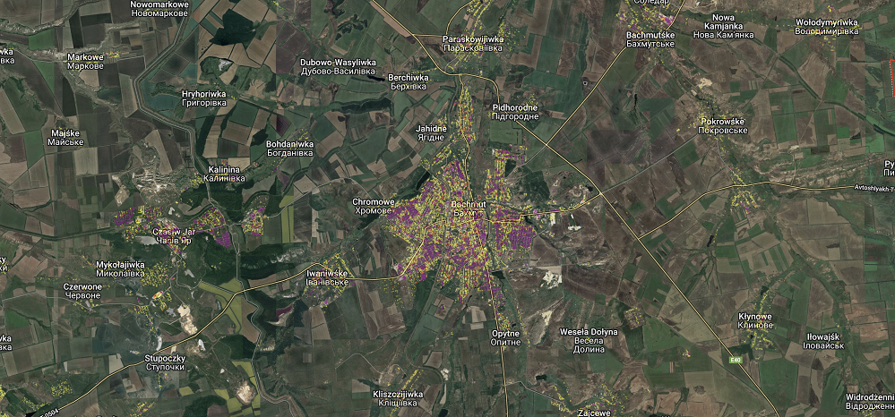
The methodology was applied to conflict-affected settlements across Ukraine, leveraging publicly available Sentinel-1 SAR data (6-day repeat, 10 m resolution) from the European Space Agency (ESA) Copernicus programme and Sentinel-2 multispectral imagery (10–20 m resolution, 5-day revisit). The Sentinel constellation’s systematic open-data policy made it feasible to construct dense image time-series spanning multiple months of conflict. The study area encompassed urban zones in both eastern and southern Ukraine, encompassing residential, industrial, and critical infrastructure assets.
Applications and Impact
The integrated satellite remote sensing framework supports:
- Post-conflict reconstruction planning for government agencies and international aid organisations
- Insurance loss estimation and war damage reporting under UN resolution frameworks
- Rapid humanitarian needs assessment to prioritise emergency shelter and utility restoration
- Legal and accountability documentation of conflict-related infrastructure destruction
Conclusion
This research demonstrates that multi-source satellite remote sensing, integrating optical and SAR data streams, substantially improves conflict damage detection beyond what either sensor achieves alone. As freely accessible Sentinel data continues to offer systematic global coverage, the framework provides a scalable, transferable model for geospatial change detection in any context where physical access is denied — from conflict zones to disaster-affected areas. The study advances the operational readiness of remote sensing for use in humanitarian response and international accountability processes.
References
2. ESA Copernicus Programme. Sentinel-1 and Sentinel-2 mission documentation. sentinel.esa.int
3. UNOSAT / UNITAR. Building Damage Assessment methodology documentation.