Scenario
Overgrazing by sheep and cattle may lead to serious land degraded problems. In some sensitive ecosystems, like tropical savannahs or steppes, overgrazing would often cause irreversible desertification.
Located in northern West Australia, a 1900 hectares farm near the little town Derby had been overgrazed before the 1970s. The environmental condition here is a coastal ecosystem with a semi-arid pseudo monsoonal climate, which is a very vulnerable in nature.
With a great expectation of harmonizing ecology, technology, and human utilization, the Birdwood Downs project was initiated. It is a demonstration project that aims at recovering degraded lands by using innovated ecological methods. By implementing pioneered means of ecology control, the invasive weeds have been removed continually and the native vegetation also recovers in this area. With limited human resources, the eco-friendly project needs innovation on tools and methods constantly for further development.
Goals
In order to attain a sustainable pasture management, two goals must be achieved:
1. For resisting the invasive weeds, the pasture area in this region should be increased.
2. To heal the overgrazed area, the nutrient value per square meter of the land should be enhanced.
Solutions
1. Collecting the spatial information with GPS devices.
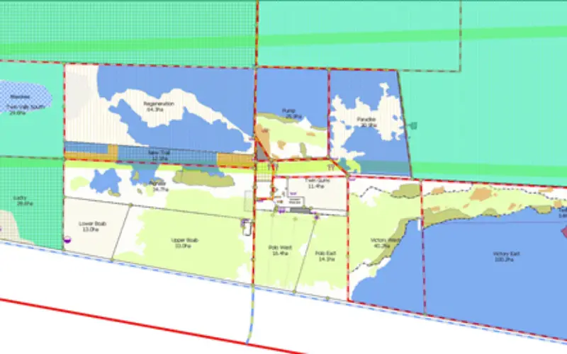
As the first step of GIS analysis, some detailed information must be collected. That includes the location of paddocks, roads, firebreaks, fences, hydraulic facilities and electricity infrastructure.
The spatial information of farm facilities was collected with GPS devices.
Because the distribution of invasive weeds and native plantation will change over time, the information of them was recorded chronologically for ensuring accuracy.
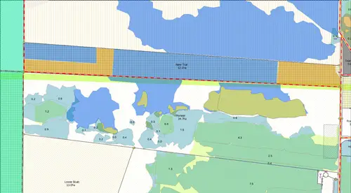
The distributions of weeds and pastures are colored differently in blue and green for identifying temporal changes.
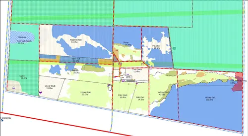
2. Analyzing the difference between two dates.
Since the distributions of weeds and pasture were collected with time attributes, any changes between different dates could be found visibly by showing two distributions on SuperGIS Desktop in the same time.
3. Assign the resources to the priority area.
After identifying the change of distributions between two periods, the manager could evaluate effects of interventions and operations. The manager will find the priority zone for further interventions. As soon as possible, the limited resource will be deployed to the priority zone for another assignment.
Results:
By using SuperGIS Desktop to assist pasture management, the goals set previously were achieved properly and effectively. The invasive species were controlled, and the productivity of land was enhanced. In the same time, the limited manpower is saved for other tasks.
Benefits:
The use of SuperGIS Desktop has improved the farm management. It is helpful and useful for the farm manager to understand natural changes and the effects of interventions. Besides, maps are effective and powerful visualization tools between the farm manager and consultants. The management team that uses maps will achieve greater progress control.