Forests always have been an important for all human beings and animals. For some forests provide shelter and some forests are source of livelihood.
Monitoring global forest footprint is of particular interest and importance for scientific community. Remote sensing technique has played a vital role in in determination and estimation of global forest cover.
Since 1972, US Landsat satellite program (optical imaging) is well known for measuring forest cover. There are certain regions in the world such as tropical forest, which are under cloud cover most of the time in a year. Optical remote sensing senor couldn’t see beyond the clouds collect and hence put the limitation on global forest cover.
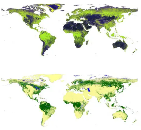
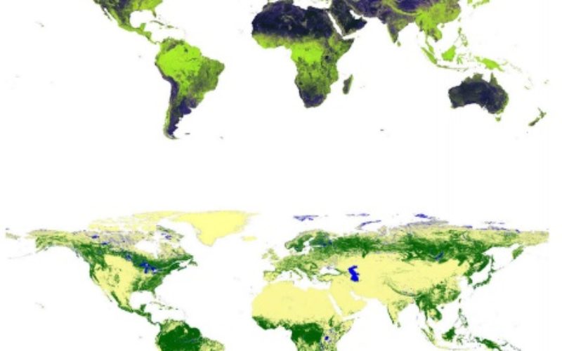
Global mosaics show phased-array type L-band synthetic aperture radar-2 color composites in (top) horizontal transmission/ reception (HH), horizontal transmission/vertical reception (HV), and HH/HV modes in red, green and blue, respectively, and (bottom) the corresponding map of forest areas (green)/non-forest areas (yellow)
Credit: SPIE
With advancement in technology, a new technology known as synthetic aperture radar (SAR) has revolutionized the remote sensing technology. SAR can see through the clouds and even in nights.
In a study by Masanobu Shimada et. al., titled “High-resolution satellite radar for mapping changes in global forest cover” has produced the global forest cover map for 2007–2010.
A high-resolution synthetic aperture radar (SAR) uses low-frequency microwaves, which enable forest and non-forest/other land use to be easily differentiated under all weather conditions. As of now only three SAR frequency bands are available for use in space. Of these three bands, the L-band of 23 cm wavelength has a higher ability to distinguish forest areas than the C-band of 5.6cm and X-band of 3 cm wavelength.
Scientist have used the phased-array type L-band SAR (PALSAR) was a high resolution multi-polarization low-noise radar, which was installed on the Advanced Land Observing Satellite (ALOS). ALOS has collected 2.1 million SAR images of 70*70 km in dimension of entire globe. They have also applied PALSAR data in HV mode to estimate forest cover and its annual variation.
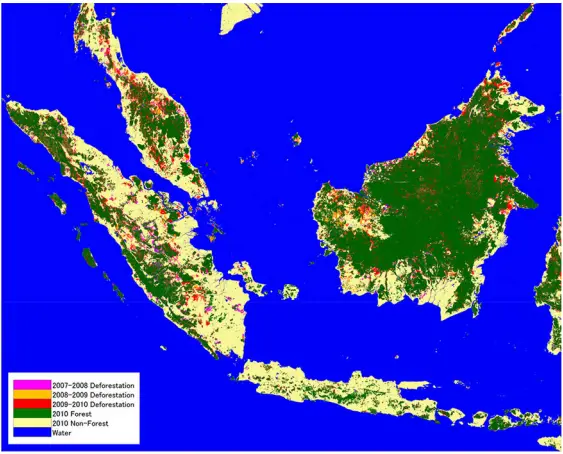
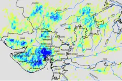
Color composite image showing four-year variation of forest cover in western Indonesia and Malaysia.Credit: SPIE
Scientists have generated four global mosaics of PALSAR horizontal transmission/horizontal reception (HH) and HV polarization data at 25 m spatial resolution using data acquired annually from 2007 to 2010.
The first estimated global forest area was 38,542,500 sq. km from the ALOS/PALSAR data set, following the Landsat-based estimation of forest area as 40,656,570 sq. km . The difference can probably be attributed to a difference in the sensitivity of optical and L-band SAR techniques in measuring forest cover.
In summary, L-band SAR backscatter provides the basis of information regarding forest and non-forest areas on a global scale. The enhanced maps and classification of land use provide a new global resource for documenting the changing extent of forests and also offer opportunities to quantify historical and future changes through comparison with data from the Japanese Earth Resources Satellite-1 SAR (1992–1998) and ALOS-2/PALSAR-2 (from 2014).
Source: SPIE
Related Story:- Radar Satellite Data for Mapping Dynamics of Deforestation and Forest Degradation