
Tag "arcgis"

CompassDrone™ to Demo Integration of DJI Video with ArcGIS at Esri Mapping Forum
CENTENNIAL, Colorado, 29 June 2017 – Full motion video (FMV) captured by the best-selling drones in the world can now be viewed, queried and used for professional mapping projects in Esri ArcGIS.

CompassCom to Debut Enhanced CompassTrac Enterprise Mobile Resource Management Solution at Esri User Conference
CENTENNIAL, Colorado, 27 June 2017 – CompassCom Software will unveil Version 7.1 of its industry leading mobile resource management (MRM) solution at the 2017 Esri User Conference. CompassTrac Enterprise, which
Esri ArcGIS 10.5 Leading Platform in OGC Compliance
The Transformative Software Receives over 30 OGC Compliance Certificates June 7, 2017 – Redlands, California—Esri, the global leader in spatial analytics, today announced that it has received over 30 compliance
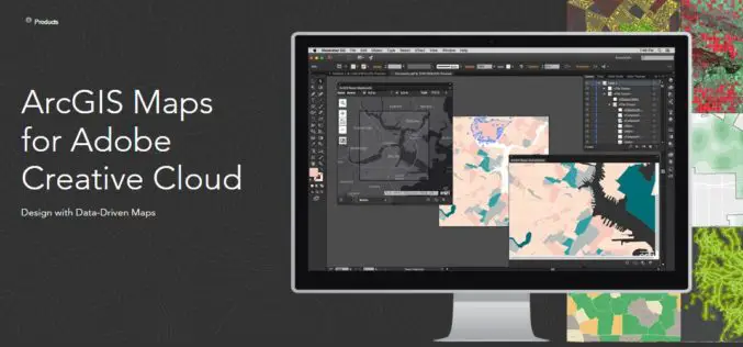
Esri Announce the Release of ArcGIS Maps for Adobe Creative Cloud!
The ArcGIS and Adobe® integration opens GIS up to an expanding group of design- and communications-focused users, who can now make direct use of spatial information. Cartographers can have the

Esri India Webinar: Mapping, Advanced Analytics and Sharing Maps with ArcGIS Desktop 10.5
Webinar: Mapping, Advanced Analytics and Sharing Maps with ArcGIS Desktop 10.5 Date: Thursday, May 25, 2017 | 11:00 AM IST onwards ArcGIS 10.5 is a big release; arguably one of

TerraGo Edge 4.0 Re-Imagines the User Experience, Adds New Mobile Features and Expands ESRI® ArcGIS® Integration Options
Using a customer-driven, agile feedback loop, TerraGo Edge undergoes a complete redesign, improves every aspect of the user experience to help get work done faster, easier and more efficiently than

mApp Your Way – Esri India App Development Challenge
mApp Your Way is an application (mobile or web) development challenge being organized by Esri India. The challenge intends to provide a platform to the institutes and students (UG/PG/Research scholars) to showcase

Esri Introduces Image Platform Bundles for Analysis, Management, and Analytics
Bundles Enable Organizations to Analyze Imagery in Minutes Instead of Hours Redlands, California—Esri, the global leader in spatial analytics, today introduced four image platform bundles that enable management and analytics

Vricon Announces Reseller Agreement with Esri
McLean, VA — March 3, 2017 — Vricon, a leading provider of highly accurate photorealistic 3D products and elevation data of the earth, today announced it has signed a reseller agreement with

Drones in Agriculture and Hands-On Drone-to-GIS Workflows
Hands-On Drone-to-GIS Workflows Sponsored by the Michigan State University Institute of Agricultural Technology, in coordination with RS&GIS and Northwest Michigan College. This unique and comprehensive, instructor-led training course is taught
