
Tag "Earth Observation"

Airbus and Scanex to Feed Russia’s Most Popular Search Engine Yandex with “One Atlas” Satellite Imagery Data
Toulouse, 24 May 2017 – Airbus Defence and Space has signed a 4-year contract with Scanex, the Russian Earth observation company, for access to optical satellite imagery via the One

PCI Geomatics Now a Planet Ecosystem Partner
MARKHAM, Ontario, Canada, May 9, 2017 — PCI Geomatics, a world-leading developer of remote sensing and photogrammetric software and systems, announced today it has become a Planet Ecosystem Partner. PCI

OGC seeks public comment on candidate OGC Web Coverage Service 2.0 Interface Standard – Earth Observation Application Profile 1.1
The Open Geospatial Consortium (OGC®) is seeking public comment on its Web Coverage Service 2.0 Interface Standard – Earth Observation Application Profile 1.1. This OGC WCS Application Profile – Earth
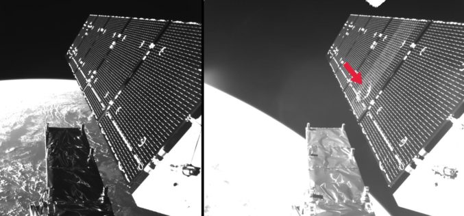
Microsatellites, Megaconstellations and Strategies for Combatting Increasing Volumes of Space Debris
7th European Conference on Space Debris in Darmstadt from 18 to 21 April Microsatellites, mega constellations, and strategies for combatting increasing volumes of space debris Approximately 350 scientists, engineers, managers

Global Push for Earth Observations Continues
The Group on Earth Observations (GEO) has been working for more than a decade to open access to Earth observation data and information, and increase awareness around their socioeconomic value.
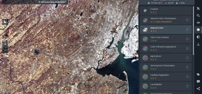
Land Viewer: On-the-Fly Earth Observation Imagery Analytics in Your Browser
Data Scientists, GIS Engineers and Software Developers from California-based company EOS have recently launched the most advanced cloud based tool to allow users, journalists, researchers, and students easily search and
Earth Firmly in View – Sentinel-2B Satellite Successfully Launched
Another ‘guardian’ of the European Earth observation programme Copernicus is in orbit Together with its ‘twin satellite’ Sentinel-2A, the new environmental monitoring system Sentinel-2B doubles the recording frequency. Every point

Airbus Partners with Bird.i for Easy Access to Fresh Earth Observation Imagery
Toulouse, 27/02/2017: Airbus Defence and Space has closed a partnership agreement with Bird.i, a global platform for accessing the world’s best satellite, airborne and drone imagery. Objective of the partnership
PCI Geomatics Marks Milestone in Cloud-Based Image Processing
MARKHAM, Ontario, Canada, January 17, 2017 — PCI Geomatics, a world-leading developer of remote sensing and photogrammetric software and systems, announced today that it is six years since it began
Reading the ABCs from Space
Contributed By:- Space and space-based technologies offer significant and unique solutions to many of real-world problems through remote monitoring and accessing information. Revolution in Earth observations from space has fueled by
