
Tag "Flood"
Transform Your Flood Preparedness with ArcGIS
Transform Your Flood Preparedness with ArcGIS Wed, Dec 9, 2015 10:30 PM – 11:30 PM IST Time is running out to prepare for historic weather events fueled by El Niño.
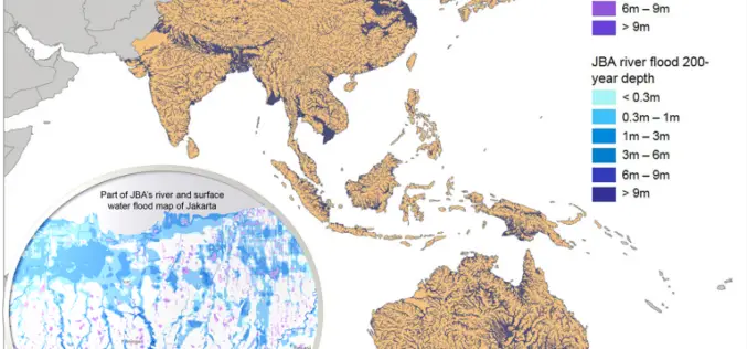
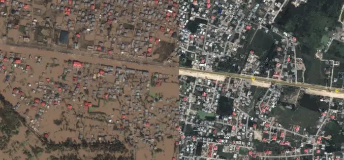
Asian Cities May See Increases in Flood Risk By 2020
Some rapidly growing Asian cities may see increases of up to 36% in the population at risk of extreme river and surface water flooding by 2020, according to recent study
Malaysia to Use UAV to Monitor Floods
The Malaysian government will be using its newly built UAV to monitor floods during the monsoon seasons. The unmanned aircraft “Unmanned Aerial Vehicle-Remote Sensing (UV-RS)”, was collaboratively developed by ARSM, Multimedia
176 Flood Forecasting Stations Established Across India
As many as 176 flood forecasting stations have been set up across the country where predictions are made during every monsoon whenever the water level exceeds limits, Water Resources Minister
J&K Moves for Geospatial Modeling of Rivers for Flood Preparedness
J&K was severely affected by flood in September 2014, learning the lesson from past the J&K Government is planning to prepare 3D maps of terrain using geospatial techniques. Digital Elevation

NASA Training on Remote Sensing Observations for Flood Management
The goal of the NASA Applied Remote Sensing Training (ARSET) is to increase the utility of NASA earth science and model data for policy makers, regulatory agencies, and other applied
Kashmir Floods Monitored By Latest Satellite Technology
Union Minister Jitendra Singh said that Kashmir floods are being constantly monitored by latest satellite technology at the National Remote Sensing Centre. “Kashmir floods are being constantly monitored by latest
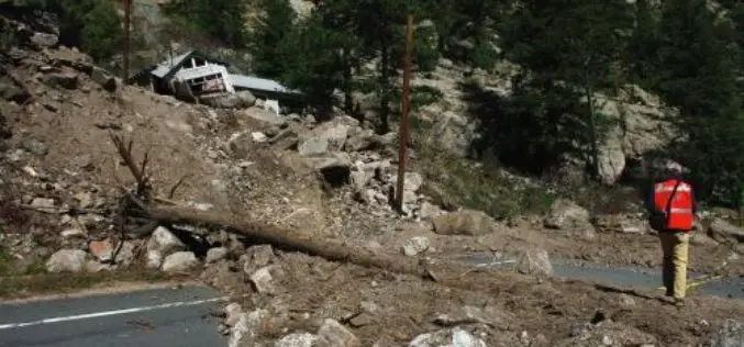
Aerial LiDAR to Study Impact of Colorado Flood on Soil Erosion
Anderson and colleagues use repeat aerial LiDAR to quantify the erosional impact of the heavy rains that inundated the Colorado Front Range in September 2013. One week of steady rain and
