Union Minister Jitendra Singh said that Kashmir floods are being constantly monitored by latest satellite technology at the National Remote Sensing Centre.
“Kashmir floods are being constantly monitored by latest satellite technology at the National Remote Sensing Centre (NRSC) of ISRO (Indian Space Research Organization),” he said.

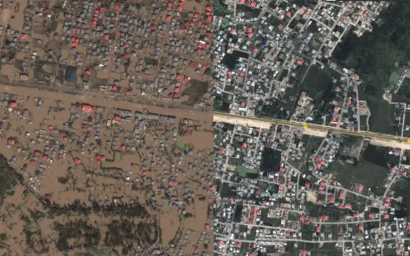
This image from the Jammu and Kashmir Crisis Map shows a before and after cross section from the city of Srinagar Sep. 2014.
Credit: Google India
Latest satellite technology at the NRSC is also keeping a close watch on the extent of flood damage, by programming its satellites for quick acquisition of data over Kashmir valley region, he added.
Singh, who is also Minister of State (MoS) for Atomic Energy and Space, said, even during the September floods, an ISRO team had been permanently kept stationed at the disposal of the state administration in Srinagar, but somehow it was not utilised to its full potential.
“This time, however, learning from the past experience, ISRO took upon itself the responsibility of collecting satellite pictures and providing vital information based on these, simultaneously to the Union Ministry of Home Affairs, National Disaster Management Authority and the Government of Jammu and Kashmir”.
In addition, the inputs were also sent to the Department of Ecology, Environment, and Remote Sensing, Government of Jammu and Kashmir to enable them to utilise these as per the local requirements, he added.
He said, “On 27th March itself, using microwave satellite data from Indian RISAT-1, the information was sent to all concerned. Further, Canadian Microwave Satellite (Radarsat-2) was also programmed for 31st March 2015 which revealed more inundation in Kashmir valley, particularly in the Anantnag area”.
This information was also disseminated to all concerned, and Indian RISAT-1 satellite has now been programmed for 2nd April, 1800 hrs.
Giving all the credit to a high degree of professional excellence and technical advancement achieved by India’s Department of Space and ISRO, Dr Singh said, efforts are also going on to acquire more satellite data from other countries under the framework of “International Charter Space and Major Disasters” to facilitate frequent and detailed coverage.
All the information obtained is also made available through Bhuvan and NDEM (private) portals, he added.
– PTI