
Tag "geospatial"

Hexagon Showcases Geospatial Enterprise Solutions at ISPRS 2016
Hexagon AB, a leading global provider of information technologies that drive productivity and quality across geospatial and industrial enterprise applications, will showcase its geospatial enterprise solutions at XXIII ISPRS (International

Enhanced Imagery, Modelling, Volumes Improve Productivity With LISTECH Neo
LISTECH, a Hexagon Geosystems brand, today announced increased functionality to its new geospatial software Neo, with terrain modelling, volume calculation and imagery offerings. With an integrated 3D/2D environment for viewing

Create, Share Geotagged, Media-rich Field Reports With New NGA Mobile App
The National Geospatial-Intelligence Agency’s latest publicly available mobile app is now available on iTunes and Google Play. The Mobile Awareness GEOINT Environment, MAGE, was developed to support first responders deploying

Geospatial Tools to Tackle Public Health in Bangladesh
According to recent news published by the University of Texas at Dallas, Geospatial information sciences (GIS) can help determine where diseases are spreading and where to target the resources needed to
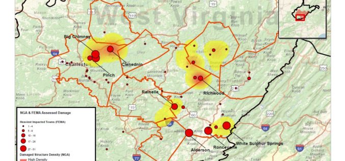
National Geospatial-Intelligence Agency Provides Expertise Response to West Virginia Flooding
As reported in a recent news bulletin by The National Geospatial-Intelligence Agency (NGA), NGA is providing geospatial expertise and damage assessments to the Federal Emergency Management Agency (FEMA) for flooded

Geospatial Corporation Announces New Quality Assurance (“QA”) and Installed Locational Integrity Management (“ILIM”) Programs for Underground Pipelines
PITTSBURGH, June 29, 2016 – (OTCQB symbol “GSPH”). Geospatial Corporation provides complete Quality Assurance (“QA”) programs and Installed Locational Integrity Management (“ILIM”) programs for underground pipelines and conduits installed via
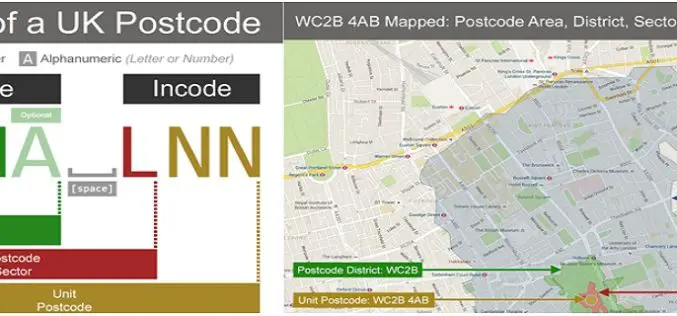
Understanding UK Postcodes and Using Them in Geospatial Systems
Contributed By:- Postcodes are very powerful within UK data – if you know the postcode of a geographical entity, you can geocode it, reasonably accurately, and using open and reliable

Airbus Defense and Space Partners with AMREL for Easy Access to Geospatial Data for GEOINT Operations
Airbus Defense and Space and American Reliance, Inc. (AMREL) have partnered to integrate GATOR (Geospatial Appliance Targeted for Operational Response) into a rugged one-box laptop solution called the GATOR Rugged

Trimble TDC100 Handheld GNSS Data Collector Combines Smartphone-Like User Experience with Professional-Grade Capabilities
Ruggedized and Highly Accurate Data Collection for GIS Professionals SAN DIEGO, Calif., June 28, 2016—Trimble (NASDAQ: TRMB) introduced today its Trimble® TDC100 handheld data collector. An entry-level Global Navigation Satellite
ISRO to Geo-tag Assets Created Under MGNREGA
India – According to recent news, a Memorandum of Understanding was signed between the Rural Development Ministry and ISRO, Department of Space for geo-tagging the assets created under MGNREGA in
