
Tag "GIS"

SuperGIS Webinar: Smart Industrial Hazard Management with GIS
Smart Industrial Hazard Management with GIS To avoid chemical accident causes fatal damage of public lives, emergency dispatchers need various resources to plan prevention and response in advanced. Join SuperGIS

Global Mapper and GM LiDAR SDKs v16.2 Released with Significant Export Processing Speed Gains
Hallowell, Maine – June 10, 2015 – Blue Marble Geographics (bluemarblegeo.com) is pleased to announce the immediate availability of version 16.2 of the Global Mapper Base Software Development Kit (SDK) along

New Autonomous Flying Drones Don’t Require GPS to Navigate
Scientists have developed a new drone navigation system that allows these aerial vehicles to navigate without relying on a GPS signal or trained personnel. With the goal of achieving autonomous
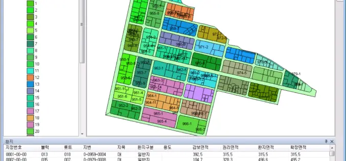
Korea Develops Land Management System by SuperGIS Engine
To meet the demands of global GIS professionals and developers, Supergeo provides with SuperGIS Engine 3.3, the COM-structured development kit, bringing various GIS developing elements, application resources and sample modules

Webinar: Getting Started with Global Mapper
Getting Started with Global Mapper May 28, 2015 In this hour-long video presentation, we provide guidance and advice for new users of Starting with the installation and registration process, we
Global Mapper Version 16.2 Now Available with Improved 3D Viewer, Upgraded Fly-Through Video Playback, and Numerous New Formats
Hallowell, Maine – May 19, 2015 – Blue Marble Geographics (bluemarblegeo.com) is pleased to announce the availability of version 16.2 of Global Mapper. This interim release includes functional upgrades and

INTERGEO 2015 Continues To Grow – Exhibition Space Almost Fully Booked Despite Expansion
Stuttgart / Karlsruhe, 20 May 2015 – INTERGEO 2015 in Stuttgart is setting new benchmarks. After attracting a record number of visitors in Berlin last year, the industry’s leading trade

Master of Science in Geographic Information Science at California State University
The College of Continuing and Professional Education (CCPE) is one of the eight academic colleges at California State University, Long Beach. It is a self-support, interdisciplinary college that works closely

Abu Dhabi Education Council Has Introduced GIS Education in Schools
According to recent news, the Abu Dhabi Education Council (ADEC) has started an initiative as major improvement in education standard with the induction of Geographical Information System (GIS) technology into

Google Maps Temporarily Shut Down Google Map Maker
Google has temporarily shut down the Google Map Maker service. Google Map Maker allows community to make edits to Google Maps. The reason the service was shut down because of
