
Tag "GIS"

Autodesk and Esri Partnering to Advance Infrastructure Planning and Design
Global Geographic Information System & Building Information Modeling Leaders Plan to Drive Integration of Spatial Intelligence and 3D Design Model Information November 15, 2017 – Redlands, California—Autodesk, Inc. and Esri, Inc.

Hexagon Safety & Infrastructure Unveils Safe City Framework
Integrated solutions and coordinated capabilities make cities safer and more resilient November 14, 2017 – HUNTSVILLE, Alabama – Hexagon Safety & Infrastructure unveiled its Safe City Framework at Smart City Expo World Congress, the

AppStudio version 2.1 for ArcGIS is Now Available
Esri’s AppStudio for ArcGIS is a pioneering tool in the GIS app development. It helps to create simple maps into beautiful mobile app friendly ready for various mobile operating systems such as iOS, Android, Windows etc, with no developer skills required.
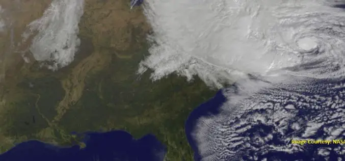
Storm Water Modeling and Flood Disaster Management Using Open Source Software
Contributed by: Geospatial data serves as an input in hydraulic simulation software and thereby the simulated results can further be transferred back to GIS system for real-world graphical representation of

AIR Worldwide Expands Its Inland Flood Modeling Capabilities to Japan
Release of Touchstone Version 5.1 includes new geospatial features BOSTON, Oct. 23, 2017 — Catastrophe modeling firm AIR Worldwide has introduced a new inland flood model for Japan along with

Remote Sensing Technology to Protect Frankincense Trees
According to recent news by Muscatdaily.com, the Remote Sensing and GIS Research Center (RSGISC) at the Sultan Qaboos University, Muscat, is assessing the use of remote sensing and GIS technology in

National Highways Authority of India Launches GIS Enabled Website and Mobile App to Monitor Highways
New Delhi – According to recent news by the ToI, the National Highways Authority of India (NHAI) launches a mobile application that will allow passengers to rate the national highways across the

Goa-based Transerve Technologies Raises $1.6mn Funds
Panji, Goa – According to recent news by the TOI and SMEPost.com, Goa-based Transerve Technologies, a company that offers geospatial technology-based SaaS solutions for sustainable growth and urban planning, has raised

OSGeo Signs MoU with U.S. Department of Interior
Osaka, Japan, 29 September 2017: The Open Source Geospatial Foundation has signed a Memorandum of Understanding with the United States Department of Interior (DOI). The agreement enables both organizations to

Reliance Energy Launches App for Complaints on Defective Street Lights
September 28, 2017, Mumbai – (IANS) – In an effort to make Mumbai streets safer after dark, Reliance Energy has launched a new app-based service for lodging complaints on defective street lights,
