
Tag "GPS"

Trimble Announces Expanded Share Repurchase Program
SUNNYVALE, Calif., Aug. 13, 2015—Trimble (NASDAQ: TRMB) today announced that its Board of Directors has approved the repurchase of up to $400 million of Trimble’s common stock and that it
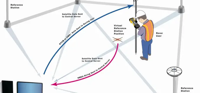
Trimble Launches VRS Now Service in New Mexico
Accurate and Reliable Centimeter-Level GNSS Performance for Geospatial Professionals SUNNYVALE, Calif., Aug. 10, 2015—Trimble (NASDAQ: TRMB) announced today the launch of Trimble® VRS Now™ correction service in New Mexico. The

China Launches 2 Satellites to Build Homegrown Satellite Navigation System
BEIJING: China launched two new satellites into space Saturday, state media reported, as it builds a homegrown satellite navigation system to rival the US’s Global Positioning System. A rocket carrying the

Utility Crews Tap into High Accuracy GPS with TerraGo Edge
Utility Crews Tap into High Accuracy GPS with TerraGo Edge July 28, 2015 12:00-12:30 PM ET When you’re working with utility infrastructure, accuracy isn’t optional. TerraGo Edge customers can get
New JavaScript Samples for Integrating GIS Online Resources
In the world of Internet sharing, there are more and more online resources freely available for you. Now in SuperGIS Server JavaScript APIs, we provide you a series of samples
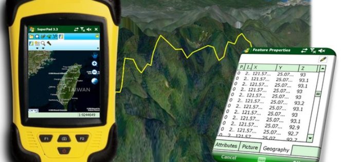
Indonesia Regional Planning and Development Sector Powers Up Mobile Mapping by SuperPad
Supergeo Technologies, the leading GIS software provider, announces that Deli SerdangRegional Sector for Planning and Development, Indonesia selects SuperPad, the mapping applicationdesigned for Windows Mobile, to power upfieldworkquality. The Sector

md4-1000 from Microdrones Reviewed By the Geo-matching Community
The Geo-matching.com website features a selection of the most important geomatics equipment, including UAS for Mapping and 3D Modelling. At www.geo-matching.com, you can compare product specifications and read users’ reviews

New Autonomous Flying Drones Don’t Require GPS to Navigate
Scientists have developed a new drone navigation system that allows these aerial vehicles to navigate without relying on a GPS signal or trained personnel. With the goal of achieving autonomous

Take a Walk on the Wild Side: Environmental Surveying and TerraGo Edge
Take a Walk on the Wild Side: Environmental Surveying and TerraGo Edge May 19, 2015 12:00 – 12:30 PM ET Environmental field surveys provide valuable insights into our world’s most

eXom Ready For Take-Off — sensefly’s Intelligent Mapping And Inspection Drone Now Available To Pre-Order
senseFly confirms release timings & technical specifications of its sensor-rich, multi-imaging rotary drone at Unmanned Systems 2015 (Hall B2, Booth 519) Unmanned Systems 2015, Atlanta, May 5, 2015 – Swiss
