
Tag "GPS"

China to Set Up 3 Civil Satellite Systems By 2020
BEIJING – China aims to finish building satellite systems for remote sensing, communications and navigation before 2020. The three satellite systems should be able to provide continuous and stable service,

How to Integrate Total Station, Level, and GNSS Data in Trimble Business Center
Webinar: How to Integrate Total Station, Level, and GNSS Data in Trimble Business Center Wed, Oct 28, 2015 7:30 PM – 8:30 PM IST (Show in My Time Zone) You’re invited

Geospatial Mapping to Curb Illegal Sand Extraction
India – The Goa State Expert Appraisal Committee (GSEAC) has issued instructions to the District Collectors to carry out survey and mapping of sand extraction lease boundaries through Global Positioning
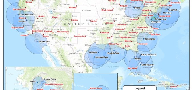
USCG Invites Public Comments on Nationwide Differential Global Positioning System (NDGPS)
In a notice by the United States Coast Guard, the Transportation Department, and the Engineers Corps dated 08/18/2015, public comments are requested on Nationwide Differential Global Positioning System (NDGPS). The Coast Guard (USCG)

Geospatial Technologies Picking Up Greater Momentum
With the advancement in Remote Sensing and development in Geographic Information System and Global Positioning System, the applications of Geospatial Technologies in various fields have picked up greater momentum, a

MapmyIndia Launches GPS Based SafeMate
MapmyIndia has recently launched GPS based SafeMate, a dedicated, personal safety device for women, children and families. SafeMate is small, lightweight and portable – the size of a matchbox –
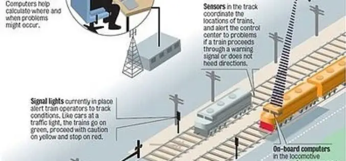
Indian Railways to Tie Up With ISRO for Enhanced Safety Using GPS Aided System (GAGAN)
Indian Railways will join hands with ISRO to get online satellite images for improving safety and enhancing efficiency. “We will undertake a massive exercise of GIS mapping of the entire

New Elevation for Nation’s Highest Peak plus 1 more
A new, official height for Denali has been measured at 20,310 feet, just 10 feet less than the previous elevation of 20,320 feet which was established using 1950’s era technology.
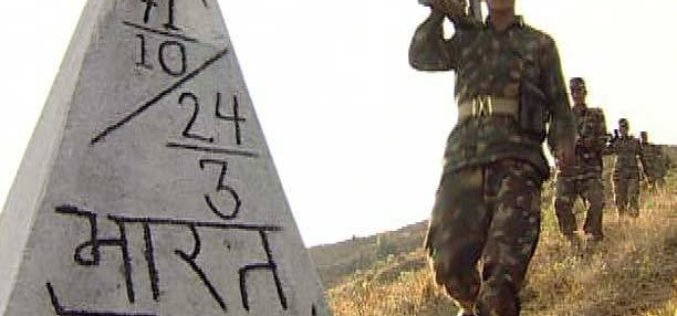
Every Nepal-India Boundary Pillar to Have GPS Observation
Nepal and India have agreed to install global positioning system (GPS) in every boundary pillar between the two neighbouring countries. The decision was taken during the Survey General-level second Nepal-India
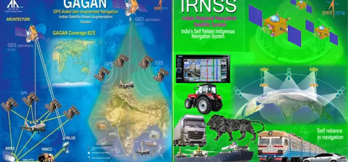
GNSS User Meet – 2015
GNSS User Meet – 2015 Organised by ISRO and AAI October 8, 2015 GNSS User Meet 2015 is jointly hosted by ISRO & AAI on the theme “Towards Self Reliance
