
Tag "map"

Join OS Experts for a Beginner’s Guide to Map Reading
Ordnance Survey adventurers will be at Cotswolds Outdoors across the country giving free map reading lessons. The workshop is for beginners and aims to give them the confidence to better explore
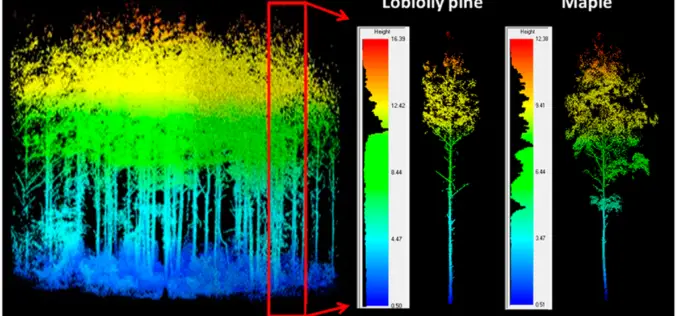
LiDAR Scanning Can Help Identify Structurally Heterogeneous Forest Areas
The inequality of tree sizes in a forest is an important factor affecting its structure and ecology. Forest management practices favouring natural regeneration can result in greater heterogeneity and complexity

GAIL to Use Drones, Satellite Mapping To Monitor Pipeline Network
GAIL (India) Ltd has decided to use drones and satellite imagery to map and monitor its pipeline network while expanding its Sahyogi (partner) scheme to detect/prevent encroachment and terror attack
Collect Points – Get The Patch
The USGS National Map Corps will award special edition patches for volunteers contributing 2,016 points between GIS Day 2015 and GIS Day 2016 Using crowdsourcing techniques, the USGS project known

A Drone with a Sense of Building Its Own Maps
MIT Technology Review – Researchers from the Swiss Federal Institute of Technology in Zurich are making drones more independent with a sense of building its own direction. They have demonstrated

Underwater Drones to Map Oceans
MIT, Hydroswarm, a new startup developing underwater drones that automatically work together, instead has visions of mapping the entire ocean. Hydroswarm is an adaptable, smart drone platform for underwater explanation.

New State Map from Indiana Geological Survey Makes Use of High-Res Imaging
BLOOMINGTON, Ind. — The Indiana Geological Survey has published a new state map that features the latest digital technology using high-resolution elevation data. The map was prepared using lidar data
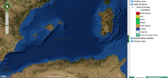
Medea S.p.A., Italy Chooses SuperGIS for Pipeline Service Management
Supergeo Technologies, the leading GIS software provider,announces that Medea S.p.A., Italy selects SuperGIS Desktop and SuperGIS Server to manage its pipeline management for enhancing citizens’ life quality. Having 30-years experience,

TerraGo Webinar: Complex 2D & 3D Map Distribution Made Easy with TerraGo GIS-Lite Applications
TerraGo Webinar: Complex 2D & 3D Map Distribution Made Easy with TerraGo GIS-Lite Applications May 5, 2015, 12:00 – 12:30 PM ET Oil & Gas companies deal with complex terrain and

Play Pac Man with Google Maps on Your Streets
Recently Google Maps has launched “Pac Man” in Google Maps. Team at Google Maps has coded a web application that lets users turn any city into classic arcade of game with hungry
