
Tag "remote sensing"

First images taken with Exelis system on DigitalGlobe’s WorldView-3 satellite released
Exelis-built integrated super-spectral imaging system consists of a telescope, sensor and shortwave infrared system ROCHESTER, N.Y., Aug. 26, 2014 – DigitalGlobe has released the first images taken with the Exelis-built (NYSE: XLS) integrated,

University of Oslo: PhD Research Fellow in Remote Sensing and Photogrammetry
The University of Oslo is Norway’s largest institution of research and education with 28 000 students and 7000 employees. Its broad range of academic disciplines and internationally esteemed research communities

OGC announces new Urban Planning Domain Working Group
20 August 2014. An OGC Urban Planning Domain Working Group (SWG) has been chartered to define the role for OGC standards and related activities within the Urban Planning discipline and
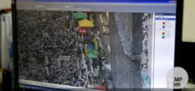
Chinese Democracy Supported by Geospatial Technologies
Since the 1997 Handover from United Kingdom to China, Hong Kong 1 July March has been the largest civil movement in HK. As the activity became more like a protest,
Paragon Addresses Unique Transportation Needs of the Animal Feed Industry
July 31, 2014 – Paragon Software Systems, Inc., a leader in vehicle routing and scheduling optimization solutions, announces a unique transportation solution to target the specific needs of the animal feed industry.

Chinese Remote Sensing Drone Sets 30-hour Flying Record
A new Chinese unmanned aerial vehicle (UAV) set a new record for the country’s remote sensing drones by flying for more than 30 hours consecutively, the UAV’s developer, the Chinese

Spymesat Mobile App Now Offers High Resolution Satellite Imagery
Orbit Logic announced today that the iPhone version of their SpyMeSat mobile app will now offer in-app purchase of recent high resolution satellite imagery. SpyMeSat users will be able to use their

Steria provides West Yorkshire Police with Command and Control solution to ensure Tour de France safety
London, UK, 4 July 2014 – Steria, a leading provider of IT-enabled business services, has today announced that West Yorkshire Police will use its SteriaSTORM Command and Control solution during ‘Le
Esri and RedSeal Bring Geospatial Analysis to Network Security
Redlands, California—Esri and RedSeal Networks are joining forces to create a geospatial framework for cybersecurity. The goal is to fully integrate existing cybersecurity and information technology (IT) data with other

Remote Sensing to Search Minerals for Turkey and Azerbaijan
In recent news, Turkey and Azerbaijan have started a joint program to explore mineral deposits using earth observation satellites. As per the agreement Turkey will build a Remote Sensing laboratory
