
Tag "SAR"

Flood Monitoring using SCATSAT-1 Satellite
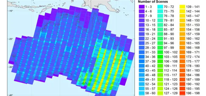
Monsoon was active over different regions of India especially in Gujarat, Eastern Uttar Pradesh, Western Bihar, Assam and lately in West Bengal during mid July 2017. Heavy rains have created

NASA ARSET Training: Introduction to Synthetic Aperture Radar
NASA ARSET Training: Introduction to Synthetic Aperture Radar Dates: Wednesday, June 28, 2017 to Thursday, July 6, 2017 Times: 12:00-1:00 p.m. and 9:00-10:00 p.m. EDT (UTC-4) Introduction: A limitation of optical satellite remote
New Open-source Software Enhances Satellite Geodesy Capability
Scientists from Geoscience Australia have released new software that will improve the ability to process big remotely-sensed satellite datasets. The new “PyRate” software being presented this week at the European
DigitalGlobe Makes MDA’s RADARSAT-2 Data Available on the Geospatial Big Data platform
WESTMINSTER, Colo.–(BUSINESS WIRE)–Jun. 5, 2017– DigitalGlobe, Inc. (NYSE: DGI), the global leader in Earth imagery and information about our changing planet, today announced an agreement with MacDonald, Dettwiler and Associates

SAR and 40cm Optical Satellite Imagery Tasking With SpyMeSat Mobile App
GREENBELT, MD (June 1st, 2017) – Orbit Logic announced today that SpyMeSat mobile app users can now send new tasking requests to the KOMPSAT-5 Synthetic Aperture RADAR (SAR) imaging satellite

PCI Geomatics Webinar Series: Geomatica InSAR
PCI Geomatics Webinar: Geomatica Object Analyst May 16, 2017 | 8AM GMT / 4PM CST & 6PM GMT / 2PM EDT In this webinar, we’ll take a deep dive into the new InSAR

NGA Solicits Input for Airborne SAR in Boosting Innovative GEOINT Topic Area
SPRINGFIELD, Va. – The National Geospatial-Intelligence Agency released the fifth topic of the agency’s Boosting Innovative GEOINT, or BIG, Broad Agency Announcement initiative, March 31, focused on airborne synthetic aperture
OmniEarth Applies Machine Learning to Multiple Satellite Sources for Improved Soil Moisture Mapping
The US Defense Advanced Research Projects Agency (DARPA) has awarded OmniEarth a Small Business Innovation Research (SBIR) Phase I contract to develop a precision soil moisture mapping model in support
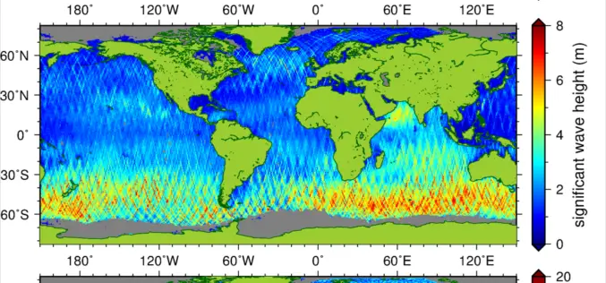
New Suite of Products Available For SRAL Instrument on the Copernicus Sentinel-3a Satellite
The Synthetic Aperture Radar Altimeter (SRAL) instrument on board Sentinel-3A delivers accurate measurements of sea surface height, significant wave height and surface wind speeds over the world’s oceans for Copernicus
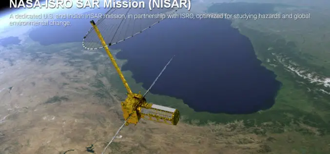
Opportunity for Young Scientist to be a Part of NASA-ISRO Synthetic Aperture Radar (NISAR) Data Program
AHMEDABAD: Here is a chance for young scientific researchers and data crunchers to be part of Isro’s ambitious NASA-ISRO Synthetic Aperture Radar (NISAR) satellite data analysis program. This will be
