
Tag "Spatial"
Monitoring and Modeling of Urban Growth Through Remote Sensing and GIS
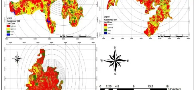
Monitoring and Modeling of Urban Sprawl Through Remote Sensing and GIS in Kuala Lumpur, Malaysia – Mukesh Singh Boori, Maik Netzband , Komal Choudhary and Vít Voženílek Kuala Lumpur is

Esri Collaborates with Microsoft to Incorporate Location Services and Spatial Analytics
Internet of Things Innovation Benefits Enterprise Organizations across Industries and Verticals The Internet of Things (IoT) inspires new ways of thinking about how we work with and share information. And
Webinar: Predicting the Future of Forests with SuperGIS Solutions
Predicting the Future of Forests with SuperGIS Solutions Thursday, September 10th 09:00 AM (GMT) Your local time For the sustainable use of bio-resources and maintain ecosystem function, Species Distribution Model

AAM Expands into India to Create AAM India
AAM officially announced its expansion into India in New Delhi on 18 May 2015. At a ceremony held in the city, AAM Group entered a partnership with Mr. Srinivasa Murthy

New South Wales Has Launched an App to Rejuvenate History of Towns
New South Wales in Australia has launched an app for residents to learn about the history of their local towns. Towns Through Time was created by Bathurst based developers Appiwork as
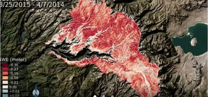
NASA: California Tuolumne Snowpack 40 Percent of Worst Year
New NASA data find the snowpack in the Tuolumne River Basin in California’s Sierra Nevada — a major source of water for millions of Californians — currently contains just 40

Introduction to GIS for Agriculture: Rangeland Focus Workshop
Introduction to GIS for Agriculture: Rangeland Focus Workshop Wednesday, April 15th, 2015, from 8:00am to 1:00pm Informatics and GIS Program (IGIS) by University of California aims to support research technology

Spatial Mapping Reveals Importance of Hauraki Gulf Waters
The most extensive spatial mapping of the Hauraki Gulf waters has identified a new area of importance for nationally endangered bottlenose dolphins, as well as demonstrating how these waters are

New National Geospatial Program Director Announced
The U.S. Geological Survey is pleased to announce the selection of Michael Tischler to the position of the Director, National Geospatial Program (NGP), starting Monday, April 6th. Mike brings a
Learn What You Can Do with ArcGIS Spatial Analysis
Go Places with Spatial Analysis Free Online Course – Learn What Spatial Analysis Can Do for You This Massive Open Online Course (MOOC) is for people who know
