
Archive
Azerbaijan Unveils New WGS-84 Topographic Maps Under Unified Geodetic System
In a significant step toward modernising cartographic data, Azerbaijan has initiated the creation of new topographic maps under the international geodetic standard WGS‑84. According to Lieutenant General Azer Aliyev, Chief
Indonesia Launches Airborne Gravity Gradiometry Mission to Map New Oil and Gas in Sulawesi
Indonesia has launched an ambitious airborne survey across Sulawesi to locate new oil and gas reserves, marking a major push to strengthen national energy security. The Geological Agency began the

India Geospatial Growth to Reach ₹1.06 Lakh Crore by 2030, Says Amitabh Kant
India’s geospatial sector is entering a decisive phase of expansion, with senior government advisor Amitabh Kant projecting the market to reach nearly ₹1.06 lakh crore by 2030. The current valuation
Malaysia Unveils GEOFHUB to Advance Geospatial Data Integration Nationwide
Malaysia has taken a major step toward modern data-driven governance with the launch of GEOFHUB, a geospatial-enabled national data platform developed by the Department of Statistics Malaysia (DOSM). By integrating
Mizoram Governor Calls for Geospatial Intelligence Development in the Northeast
The Governor of Mizoram has issued a strong appeal for wider adoption of modern mapping and Earth-observation tools, saying they are essential for shaping a climate-ready and sustainable future for
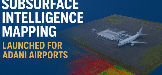
Subsurface Intelligence Mapping: Genesys Launches India’s First 3D Survey of Adani Airport
In a major stride toward India’s infrastructure modernisation, Genesys International has launched the country’s first comprehensive 3D subsurface mapping project, specifically for six airports operated by Adani Group. The contract,

The Fastest Way to Georeference Maps Online: Georeferencer.ai
Georeferencer.ai is here to make georeferencing maps faster, easier, and more accessible than ever. With just a few clicks, anyone can align maps to real-world coordinates without special software or

ESA and GEOSAT Join Forces to Accelerate Space Entrepreneurship and Sustainable Innovation
The European Space Agency (ESA) has signed a Letter of Intent with GEOSAT, marking an important milestone in advancing Europe’s space commercialisation landscape. Through ESA’s Partnership Initiative for Commercialisation (EPIC),

UK Bolsters Satellite PNT Resilience with New Cross-Government Push
The UK Hydrographic Office (UKHO) has taken an important step toward enhancing the United Kingdom’s Positioning, Navigation and Timing (PNT) infrastructure by hosting the first cross-government geodesy and PNT working

Esri India Launches Bharat ENVI — Satellite Data Analytics Boost for India
Bharat ENVI is a newly launched geospatial image-processing and analysis software by Esri India. It integrates the widely used Indo ArcGIS platform with advanced remote sensing tools — enabling Indian
