
Archive

Discover the Northwest with Revised Montana Maps
Just in time to explore the great outdoors this summer, newly designed US Topo maps covering Montana are now available online for free download. US Topo maps now have a crisper,

GIS To Prepare Tribal Map of India: Orman
In recent news, Union Tribal Affairs Minister Jual Oram said his ministry is planning to information technology to closely monitor various tribal welfare plans and projects for development of tribal areas.
RFP: For procurement of “CMS AND GIS BASED CENTRAL IMD WEBSITE”
India Meteorological Department Mausam Bhawan, Lodi Road New Delhi-110003 For procurement of “CMS AND GIS BASED CENTRAL IMD WEBSITE” Tender Enquiry No. CPU/52/0414/9679 Dated: 28.05.2014 Director General of Meteorology (DGM),

SuperSurv 3.2 for iOS Supports Cloud Storage
SuperSurv 3.2 for iOS, the newest mobile GIS app released by Supergeo, enables users to import data through cloud hard drive and supports more US local coordinate systems, providing iOS

EagleView Technologies Announces Pictometry® CONNECTMobile™
(Bothell, Wash., June 3, 2014) – EagleView Technologies, Inc., a leading technology provider of aerial imagery, data analytics and GIS solutions, announces the launch of CONNECTMobile™. This latest mobile release
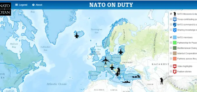
NATO HQ Launches Interactive Web Map Based on Esri Technology
People Can Now Easily View NATO Activities, Operations, Partners, Video, and More Redlands, California—The North Atlantic Treaty Organization (NATO) has just released “NATO on Duty,” an interactive, multi-media web map
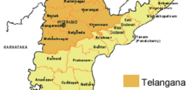
Telangana Official Map Yet to be Prepared
Telangana formally became the country’s 29th state today but it would take a while before it is reflected in the official geographical and political map as the Ministry of Home

Spatial Decision Support Systems Principles and Practices
Spatial Decision Support Systems Principles and Practices Ramanathan Sugumaran John DeGroote Spatial decision support systems (SDSS) are designed to help decision makers solve complex spatially related problems and provide a

Back to Back Three Satellite Launches by Iran Next Year
The Zafar, Tolou and AutSat are the three Iranian remote sensing satellites are line up to launch using Simorgh Launcher in the coming year (to start March 21, 2015). These
Hexagon Geospatial Enhances ERDAS IMAGINE 2014
New Service Pack Enhances Workflows, and Supports New Formats and Sensor Models NORCROSS, Ga., May 30, 2014 – Hexagon Geospatial announces the release of a new service pack for ERDAS
