
Archive

eBee from senseFly Reviewed by the Geo-matching community
The Geo-matching.com website features a selection of the most important geomatics equipment, including UAS for Mapping and 3D Modelling. At www.geo-matching.com, you can compare product specifications and read users’ reviews
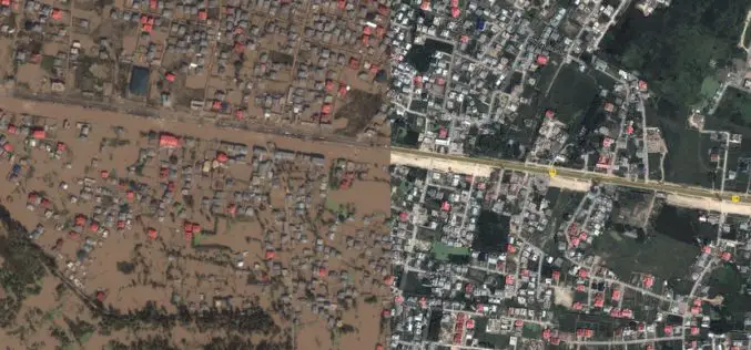
J&K Moves for Geospatial Modeling of Rivers for Flood Preparedness
J&K was severely affected by flood in September 2014, learning the lesson from past the J&K Government is planning to prepare 3D maps of terrain using geospatial techniques. Digital Elevation
Better Business Decisions with Esri’s Up-to-Date Data and Reports
Redlands, California—Having up-to-date information is crucial for accurate decision making in business. Esri’s ArcGIS platform provides access to updated demographics, Tapestry Segmentation, Retail MarketPlace, consumer spending, marketing potential, and traffic

INTERGEO 2015 Continues To Grow – Exhibition Space Almost Fully Booked Despite Expansion
Stuttgart / Karlsruhe, 20 May 2015 – INTERGEO 2015 in Stuttgart is setting new benchmarks. After attracting a record number of visitors in Berlin last year, the industry’s leading trade

Ordnance Survey Maps Undergo Their Greatest Innovation For Over 200 Years
Over the next 12 months Ordnance Survey is to replace all 607 of its current paper map titles (OS Explorer, OS Landranger and OS Tour series) with a new design and
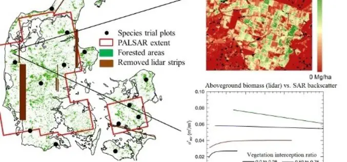
L-Band SAR Backscatter Related to Forest Cover, Height and Aboveground Biomass at Multiple Spatial Scales across Denmark
L-Band SAR Backscatter Related to Forest Cover, Height and Aboveground Biomass at Multiple Spatial Scales across Denmark – Neha P. Joshi, Edward T. A. Mitchard, Johannes Schumacher, Vivian K. Johannsen, Sassan Saatchi and

Master of Science in Geographic Information Science at California State University
The College of Continuing and Professional Education (CCPE) is one of the eight academic colleges at California State University, Long Beach. It is a self-support, interdisciplinary college that works closely
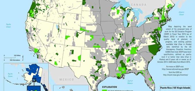
State and Regional 3DEP Stakeholder Workshops Underway
The U.S. Geological Survey National Geospatial Program is developing the 3D Elevation Program (3DEP) to respond to growing needs for high-quality topographic data and for a wide range of other
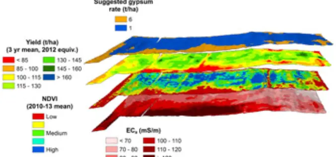
Crop and Soil Mapping Boosts Potential for Increased Yields
A research project started at 2008 by Sugar Research Australia (SRA) with additional support from QDAFF, the collaborative project brings together research expertise from CSIRO, the University of Southern Queensland’s
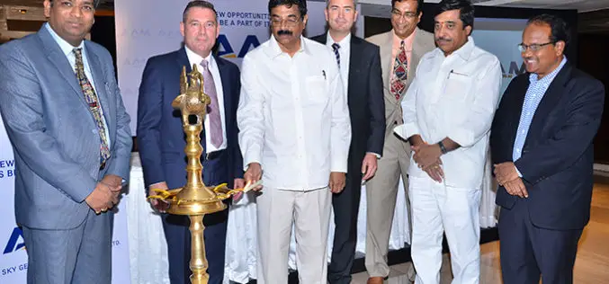
AAM Expands into India to Create AAM India
AAM officially announced its expansion into India in New Delhi on 18 May 2015. At a ceremony held in the city, AAM Group entered a partnership with Mr. Srinivasa Murthy
