
Archive

Crop Mapping Drones Win MIT $100K
Team developing drones that scan and monitor crop health takes grand prize at 25th annual competition MIT News Office , May 14, 2015 – Drones are positioned to change people’s lives, with
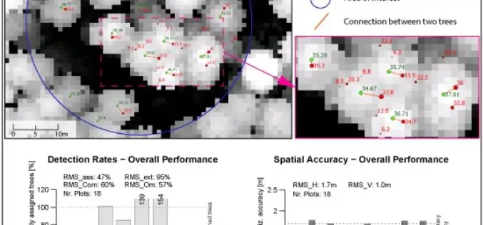
A Benchmark of Lidar-Based Single Tree Detection Methods Using Heterogeneous Forest Data from the Alpine Space
A Benchmark of Lidar-Based Single Tree Detection Methods Using Heterogeneous Forest Data from the Alpine Space – Lothar Eysn, Markus Hollaus, Eva Lindberg, Frédéric Berger, Jean-Matthieu Monnet, Michele Dalponte, Milan Kobal, Marco Pellegrini, Emanuele

Graduate Degree Track in Applied Remote Sensing by the University of Miami
The University of Miami is one of the largest private research institutions in the southeastern United States. The University’s mission is to provide quality education, attract and retain outstanding students,

New South Wales Has Launched an App to Rejuvenate History of Towns
New South Wales in Australia has launched an app for residents to learn about the history of their local towns. Towns Through Time was created by Bathurst based developers Appiwork as

Timmons Group Announces Upcoming Webinar on Esri Roads and Highways
Timmons Group, a leader in innovative geospatial solutions, announced today their upcoming webinar titled “LRS Basics and Roads and Highways” scheduled for May 21, 2015 from 1-2 PM EST. Presented

Abu Dhabi Education Council Has Introduced GIS Education in Schools
According to recent news, the Abu Dhabi Education Council (ADEC) has started an initiative as major improvement in education standard with the induction of Geographical Information System (GIS) technology into
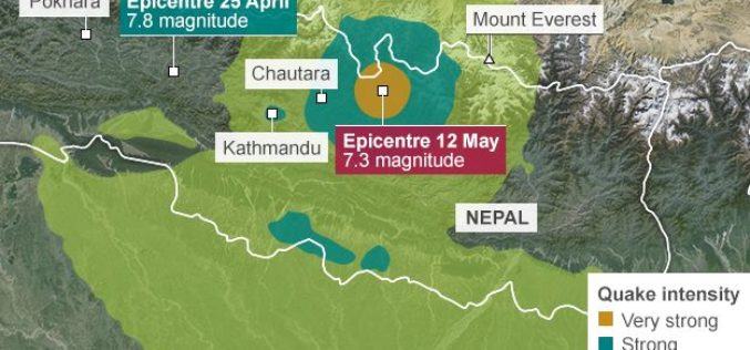
Geological Survey of India Mapping Nepal Earthquake Aftershocks
In a bid to aid community preparedness, scientists at the Geological Survey of India (GSI) are monitoring the aftershocks in various parts of the country following the massive April 25

GPS World Live Webinar: Say Goodbye Proprietary Devices, Hello TerraGo Edge
GPS World Live Webinar: Say Goodbye Proprietary Devices, Hello TerraGo Edge May 28, 2015, 1:00PM – 2:00PM (ET) Say goodbye to expensive, single-use GPS handheld devices. That’s not the way
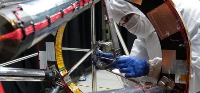
Taiwan has Indigenously Built its First Optical Remote Sensing Instrument for FORMOSAT-5 Satellite
In recent news from Focus Taiwan, the National Applied Research Laboratories (NARLabs) of Taiwan, announced that country has indigenously built the first optical remote sensing instrument (RSI) in Taiwan that
Boundless Releases OpenGeo Suite 4.6
Latest Version of Leading Open Source Geospatial Software Improves Styling, Performance, and Reliability New York, NY & Washington, DC – May 12, 2015 — Boundless, the leading provider of Spatial
