
GIS

Sri Lanka Survey Department Released New Sri Lanka Maps
Colombo [Sri Lanka] , May 31, 2018 – After 18 years, the Sri Lanka Survey Department (SLSD), the national surveying and mapping organization under the Ministry of Land and Land
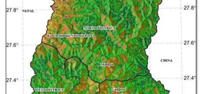
Geodiversity Map of Sikkim Himalayas to Aid Conservation
IANS – In a maiden effort, researchers have mapped the plant diversity of the Sikkim Himalayas on the basis of geography and climate data, to create a ‘geodiversity index that

Genesys International Corporation Ltd Bags Prestigious TAPI Mapping Project Using LIDAR
Genesys International Corporation Ltd has been awarded the prestigious TAPI mapping project using LIDAR. won against international competition – this project win is an extension of the company’s expertise in

Sketch Design for New Belarusian-Russian Satellite in 2019
MINSK, 11 April (BelTA) – There are plans to finish the sketch design for a new Belarusian-Russian satellite in 2019, BelTA learned from Boris Chernukha, Deputy Director for Science of
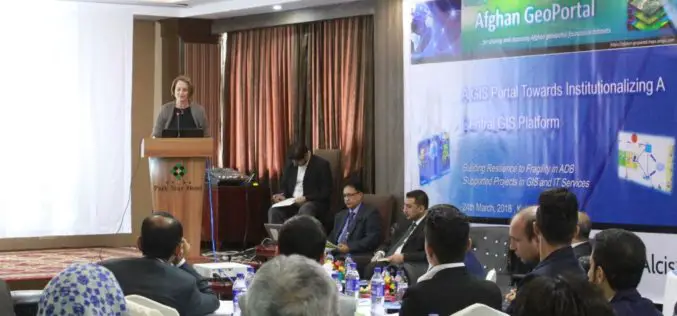
Asian Development Bank and the Govt of Afghanistan Launched “Afghan GeoPortal” to Improve Data Access, Sharing
KABUL, AFGHANISTAN (26 March 2018) — The Asian Development Bank (ADB) and the Government of Afghanistan launched the “Afghan GeoPortal” to help increase the Government of Afghanistan’s access to accurate

India Fastest Growing Market for UAVs; To Touch $886 mn by 2021
New Delhi, Mar 26 (PTI) India is one of the fastest-growing markets for unmanned aerial vehicles (UAVs), and one of the top UAV importers for military purposes worldwide, says a

Tata Power Delhi Distribution Ltd Implemented GPS Mapping Technology for Speedy Location and Repair of Faults
According to recent news reported by the Energy World, in a first for India, Tata Power Delhi Distribution Ltd (TPDDL) has implemented GPS mapping and Radio Frequency Identification Detector (RFID) Marker installation

Bangalore Started Rooftop Solar Energy Potential Mapping Using Aerial LiDAR
According to recent news reported by The Hindu, Over the fortnight, a helicopter armed with LiDAR system will fly across the city, mapping its potential to generate rooftop solar energy. The

Punjab to Launch Mobile App for Farmers to Manage Crop Residue
Chandigarh Feb 11, 2018 (PTI) – To help in management of stubble, the Punjab government today said it will launch a mobile app to facilitate the farmers for custom hiring

IIT-Roorkee Professor Develops New Technology for Aerial Survey
According to recent news by the Hindustan Times, Professor Kamal Jain at the civil engineering department of the IIT used a drone for taking videos with an interactive web map to demonstrate
