
Software
Esri Announces the Release of Drone2Map for ArcGIS
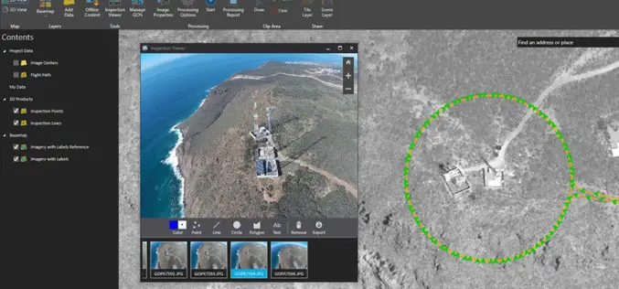
Drone2Map for ArcGIS is Now Available Esri is pleased to announce the release of Drone2Map for ArcGIS, our new desktop app that allows you to turn drone-captured still imagery into

Icaros Releases 4.2.2 of OneButton UAS Image Processing Software
FAIRFAX, Virginia, USA – Icaros Inc., a leading provider of aerial imaging software, is pleased to announce Release 4.2.2 of OneButton. The release contains new features and improvements as well as
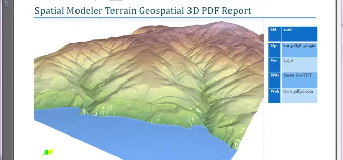
PDF3D Releases 3D Geospatial PDF Plugin for ERDAS IMAGINE at HxGN Live
PDF3D Plugin Released to Create High Quality Geospatial 3D PDF Documents from within ERDAS IMAGINE Spatial Modeler 2016. Anaheim California, June 13th, 2016 – Technological leaders, PDF3D, have today announced
Global Mapper 17.2 Released with New Map Book Creation Tool and Cutaway Terrain View
Hallowell, Maine – May 17, 2016 – Blue Marble Geographics (bluemarblegeo.com) is pleased to announce the immediate availability of Global Mapper version 17.2. This upgrade to the version 17 release
QGIS 2.14.1 Now Available from Boundless!
Boundless QGIS 2.14.1 is out the door! We are excited to share with your the latest offering of premier open-source desktop GIS technology. This release is available here and is

World Geocoder for ArcGIS
Redlands, California—Esri released World Geocoder for ArcGIS today. World Geocoder for ArcGIS enables users to securely map global addresses behind a firewall so that sensitive data is never exposed. Geocoding

Esri Releases Drone2Map for ArcGIS
App Turns Still Imagery Captured by Drones into 2D and 3D Products Redlands, California—Drone2Map for ArcGIS, released today by Esri, turns raw still imagery from drones into professional 2D and
Global Mapper 17.1 Released with Improvements to Map Publishing and Analysis Tools
Hallowell, Maine – February 2, 2016 – Blue Marble Geographics (bluemarblegeo.com) is pleased to announce the availability of Global Mapper version 17.1. This intermediate upgrade to the version 17 release

Geographic Calculator 2016 Now Available with Significant Upgrades in Design and Performance
Hallowell, Maine – December 15, 2015 – Blue Marble Geographics (bluemarblegeo.com) is pleased to announce the release of the Geographic Calculator 2016. This major upgrade to the industry’s preeminent geodetic
Boundless Participates in Release of GeoNode 2.4
Boundless Hosts Code Sprint in New Orleans and Announces Important Functionality in GeoNode 2.4 Boundless, the leading provider of open source geospatial software and services, today highlighted the latest release
