- The TerraSAR-X satellite has been in service for twice the planned time.
- The data has been providing valuable insights regarding changes to the Earth’s surface for the past 10 years.
- Focus: Space, Big Data, Climate Change, Remote Sensing, Earth Observation
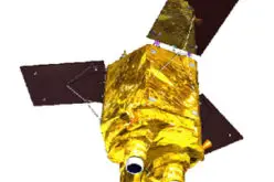
Designed to return unique images of the Earth for five years, the German radar satellite TerraSAR-X has outdone itself. The satellite has been in operation for twice that time – and there is still no end in sight to its service. Since its picture-perfect launch on 15 June 2007 from the Russian cosmodrome in Baikonur, the German Aerospace Center (Deutsches Zentrum für Luft- und Raumfahrt; DLR) TerraSAR-X mission
“TerraSAR-X has stood for outstanding research and development performance and top-level satellite operation for 10 years. To this day, the mission continues to set standards in precision and image resolution. Thanks to its globally unique radar technology, TerraSAR-X has opened up a new era in remote sensing and paved the way for the equally successful follow-up mission, TanDEM-X. I am pleased that both satellites have been fully functional and efficient,” emphasises Pascale Ehrenfreund, Chair of the DLR Executive Board.
The first TerraSAR-X image: Russia, west of Volgograd
TerraSAR-X and its twin TanDEM-X, which was launched three years later, have been flying in formation since 2010. Together, they generate the highest resolution three-dimensional images of the Earth’s surface. To this day, the special mission concept of TanDEM-X, the first bistatic SAR interferometer in space, developed at the DLR Microwaves and Radar Institute, is one-of-a-kind.
“With the TerraSAR-X mission and its successor mission TanDEM-X, we have also entered new territory in industrial policy: TerraSAR-X was the first space project undertaken between DLR and the aerospace industry as a public-private partnership (PPP) on the initiative of the DLR Space Administration with funds from the German Federal Ministry of Economic Affairs and Energy,” added Gerd Gruppe, DLR Executive Board Member responsible for the Space Administration.
Comparison of SRTM (2000) and TerraSAR-X / TanDEM-X (2013) data of the opencast mine Garzweiler.
Credit: DLR
Big Data for Earth observation
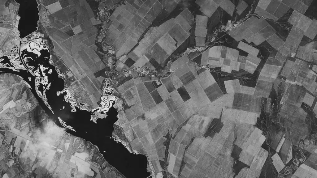
The satellite has already delivered 303,714 images. The data is received via a global network of ground stations and processed and evaluated by experts at the DLR Earth Observation Center (EOC). Even the first analyses document indisputable details of climate change, including the retreat of glaciers across the globa. Approximately 1000 scientists from more than 50 countries are now using the data for their research – and demand is on the rise. The global radar images are of particular value to environmental and climate research. DLR ensures access to the images in the long term in the German Satellite Data Archive in Oberpfaffenhofen.
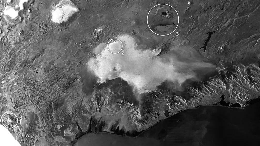
Iceland: Infamous volcanoes
In this time, the German Space Operations Center (GSOC) has sent more than 1.85 million commands to TerraSAR-X, and an additional 1.4 million commands to control the orbiting TanDEM-X satellite. A particular challenge, both during the development and in operation, was and is the ‘double-helix dance’ of the two radar satellites. The tightest flight formation between TerraSAR-X and TanDEM-X was at a distance of 120 metres distance perpendicular to the direction of flight – at an average speed of 7.6 kilometres per second. The exceptional performance and success of the mission is not least down to the close interdiscplinary collaboration within DLR. In Oberpfaffenhofen, almost 100 staff from four DLR institutes have combined their expertise such that they have mastered the entire process chain of the TerraSAR-X and TanDEM-X mission for 10 years now.
The future
The exceptional lifetime of the satellite has been possible thanks to careful operation and robust construction. Only about half of the fuel supply has been consumed and the performance level of the batteries is approximately 72 percent, so the experts expect TerraSAR-X will continue to operate for another five years. The twin satellite TanDEM-X is also showing no signs of fatigue, meaning that more high resolution elevation images will be generated and the global data set enhanced by autumn 2017. The focus is on areas undergoing strong processes of change, and are therefore of particular scientific interest. These include the coastal regions of the Antarctic, Greenland and the permafrost regions, and the Amazon rainforest.

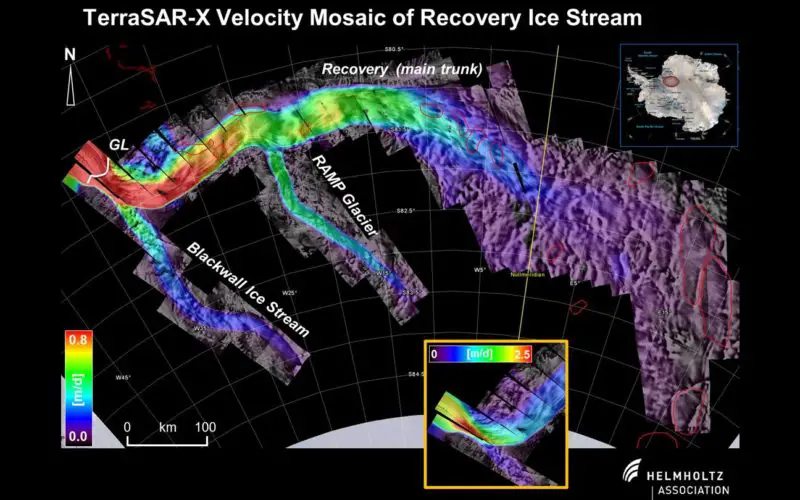
Determination of glacier movements
“The new images are also being used for the demonstration and preparation of the Tandem-L mission. With Tandem-L, DLR has designed a new satellite mission to observe how Earth is changing – for 10 years, on a weekly basis, at high resolution and in three dimensions. Such data will be of inestimable value for science and politics,” explains Hans Jörg Dittus, DLR Executive Board Member for Space Research and Technology. With regard to the extent and effect of climate change, Tandem-L could provide important information that is still lacking – for improved scientific forecasts and the social and political recommendations for action that are based on this. The concept builds on the experience and exceptional success of the TerraSAR-X and TanDEM-X missions. If the mission proposal gets the ‘green light’, Tandem-L will take radar remote sensing into the next era of technology and applications in 2022.
With the X-Band SAR family, Germany has developed a globally recognised expertise and a unique selling point for decades. In order to ensure this leadership role in the future, the continuation of the X-Band family is being carried out at the DLR Space Administration. The future lies in an even higher resolution with wider observation swaths. This is intended to continuously provide the scientific, governmental and commercial stakeholders with data.
About the mission
TerraSAR-X has been delivered under contract to the German Aerospace Center, using funds provided by the German Federal Ministry for Economic Affairs and Energy. It is the first German satellite to be produced under a so-called public private partnership (PPP), between the DLR and Airbus Defence and Space GmbH(formerly Astrium). The use of TerraSAR-X data for scientific purposes is the responsibility of DLR (also responsible for the design and execution of the mission and control of the satellites). Airbus Defence and Space GmbH contributes to the costs of development, construction and deployment of the satellites. Infoterra GmbH, a subsidiary company established specifically for this purpose by the former Astrium GmbH, took over commercial marketing of the data.
Contacts
Bernadette Jung
German Aerospace Center (DLR)
Tel.: +49 8153 28-2251
Fax: +49 8153 28-1243
mailto:Bernadette.Jung@dlr.de
Prof. Dr.-Ing. Alberto Moreira
DLR German Aerospace Center (DLR)
Head
Microwaves and Radar Institute
Tel.: +49 8153 28-2306
Fax: +49 228 447-747
mailto:Alberto.Moreira@dlr.de
Prof. Dr.rer.nat. Michael Eineder
German Aerospace Center (DLR)
Earth Observation Center (EOC)
Remote Sensing Technology Institute
Tel.: +49 8153 28-1396
Fax: +49 8153 28-1420
mailto:Michael.Eineder@dlr.de
Dr.rer.nat. Edith Maurer
German Aerospace Center (DLR)
Space Operations and Astronaut Training
Tel.: +49 8153 28-3313
mailto:Edith.Maurer@dlr.de
Michael Bartusch
German Aerospace Center (DLR)
Space Administraton
Tel.: +49 228 447-589
Fax: +49 228 447-747
mailto:Michael.Bartusch@dlr.de