This past week was intense – the most powerful hurricane ever recorded in the Western Hemisphere made landfall, just missing major population centers and avoiding catastrophic damage. Three days later, a magnitude 7.5 earthquake struck near the Hindu Kush region in Afghanistan. Immediately the Humanitarian OpenStreetMap Team activated, and hundreds of volunteers around the world began mapping these vulnerable areas to help first responders, aid organizations, and the local governments.

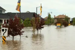
Nearly 500 volunteers mapped 5.6k miles of road and 72k buildings in the 72 hours following Hurricane Patricia.
Credit: Mapbox
The response to both disasters was amazing, with hundreds of volunteers mapping thousands of miles of roads and hundreds of thousands of buildings. This is about making a better map for everyone. In times of great struggle you can often see the greatest virtues of community coming together and last week was no exception.
Here are a few highlights of how Mapbox helped with coordination, data tracing, and imagery:
- Mapping for hurricane response in Mexico
- HOT Responds to Afghanistan Earthquake
- Afghanistan earthquake satellite imagery
To learn more about the Humanitarian OpenStreetMap Team, and to receive alerts for their next activation, visit the HOT OSM site.
If you’re ready to get started, dive right into the OSM Tasking Manager!
– Mapbox – email content