
Tag "Digital Mapping"

SI Imaging Services Signs MoU with Luciad NV in Belgiumand G-Ros in Korea
On June 14th at the Grand Hyatte Seoul, the SI Imaging Services has signed a Memorandum of Understanding (MoU) with the Luciad NV in Belgium and its certified reseller in
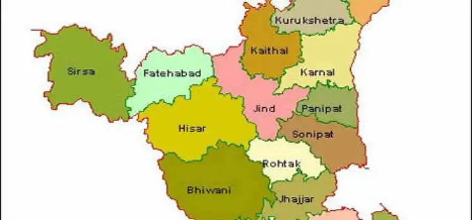
HARSAC Uses Drones to Create “Most Accurate Maps” of Gurugram for Land Records Management
New Delhi : Haryana State Remote Sensing Application Centre (HARSAC) and local administration made optimum use of the technology at their disposal as they used 24 satellites and drones to

Flipkart Launches its Flipkart Maps Services
According to recent news by The Economic Times, Flipkart, the online retail giant is about to make its debut on MapUnity, a Social Technology Lab by Dr. Ashwin Mahesh. MapUnity
UN Expert Committee Outline the Future Trends in Digital Mapping
A new report setting out the five to ten-year vision of the rapidly growing geospatial information industry has been published by the United Nations Committee of Experts on Global Geospatial

Geospatial Technology Helps Indian Air Force to Rediscover Lost Land
After a year of search with the help of satellite mapping and pain staking ground survey, a team of UP Board of Revenue and Indian Air Force (IAF) has been

Digital Mapping of Alaska Completed Halfway
As reported in Alaska Dispatch News, Alaska is one-fifth the size of the U.S. and covered with treacherous terrain, because of which creating map of such areas is quite difficult in

Registers of Scotland Urged Landowners to Register for Digital Mapping Process
Registers of Scotland (RoS) is a national agency and is the non-ministerial department of the Scottish Government responsible for compiling and maintaining records relating to property. Registers of Scotland is

NIDM Emphasizes On the Need of Digital Mapping
In recent news by ToI, ahead to the planning of Kumbh Mela in Nashik, the National Institute of Disaster Management (NIDM) has suggested digitised mapping of Nashik to create a

Railways to Digitize Mapping of Land Records to Counter Encroachment of Railways Land
The Union Railway Minister Shri Suresh Prabhakar Prabhu has said that encroachment on the Railway Land is a serious issue and to counter this, digitized mapping of land records has

Pakistan to Introduce Smart Phones for Digital Mapping of Dengue
According to recent news, Dengue Prevention and Control Programme (DPCP) Sindh (Pakistan) to introduce smart phones for digital mapping of high-risk areas of dengue larva breeding points, patients and
