
Tag "Geographic Information System"

Australian Utility Sets Global Technology Benchmark
Queensland Urban Utilities (QUU) has won the renowned Esri Special Achievement in GIS (SAG) Award for Q-Hub, a technology system which provides a real-time location-based view of the utility’s entire
Esri Launches National Green Infrastructure Initiative for Planning
Maps, Data Empower Local Communities to Identify, Protect, and Connect Nature’s Network Redlands, California—Esri, the world leader in geographic information system (GIS) technology, has launched a suite of public mapping

Indonesia Using Geoportal to Monitor the Condition of Public Infrastructure
The Ministry of Public Works and Public Housing’s Institute of Road Engineering, Agency for Research and Development (Pusjatan) has unveiled a new smart mapping portal called Geoportal Pusjatan, which was
Punjab Government to Utilise Remote Sensing Satellites for Development
Punjab government on Monday said India should make use of its remote sensing satellites more efficiently for development in agriculture and rural and urban planning. “India, having the largest constellation
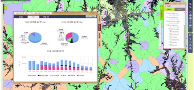
Korea to Launch Spatial Data Infrastructure Building Projects in Central Asia, Africa
According to recent news by Business Korea, The National Geographic Information Institute (NGII) is planning to launch spatial data infrastructure (SDI) building projects in Kazakhstan, Kyrgyzstan, Uzbekistan and Mongolia. The
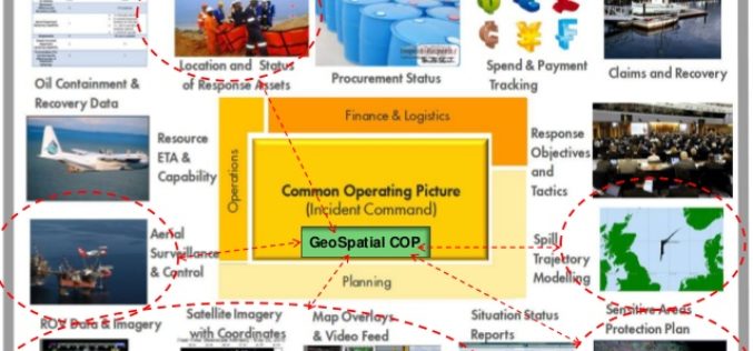
OGC announces Oil Spill Response Common Operating Picture Recommended Practice
02 March 2016: The Open Geospatial Consortium (OGC®) announces that the International Association of Oil & Gas Producers (IOGP) through the Geomatics Committee and IPIECA (the global oil and gas
Esri Announces Big Changes to Small Government Enterprise License Agreement Program
Now Governments with Populations Up to 250,000 Are Eligible Esri has announced a significant change to its Small Municipal and County Government Enterprise License Agreement (ELA) program. Municipal and county

OGC Announces Standard That Makes Complex Environmental Data Easier To Use in GIS
The membership of the Open Geospatial Consortium (OGC) has approved the OGC CF-netCDF 3.0 encoding using GML Coverage Application Schema, an extension to the OGC CF-netCDF 3.0 encoding standard. The
Abu Dhabi to Host Esri Middle East and North Africa User Conference
Emirate Serves as the Smart Government Role Model for All Nations in the Region to Replicate Redlands, California—For almost a decade, Abu Dhabi, United Arab Emirates, has typified smart government—primarily

China’s Geoinformation Industry to Touch $6.6 Billion: Official
Beijing, Nov 10, 2015 – China’s geoinformation industry is booming with the output value expected to touch 360 billion yuan (USD 56.6 billion) this year, an increase of 22 per
