
Tag "geospatial"

Postdoc. in Geospatial Visualization
The Leibniz Institute for Regional Geography (Leibniz-Institut für Länderkunde, IfL) is the only non-university research institute for geography in Germany. The institute currently has around 75 employees and an annual

Learn What Location Analysis Can Bring to Your Business
Esri’s free classes highlighting the benefits of location analysis continue with The Location Advantage. The course is business oriented and explores market planning, site selection, market analysis, and supply chain

myWorld 3, A Significant Leap Forward for Geospatial Mobility Platforms
Ubisense Group plc, a leader in enterprise location intelligence solutions, has released myWorld 3, a significant leap forward for the state of the art in modern geospatial mobile platforms. Key
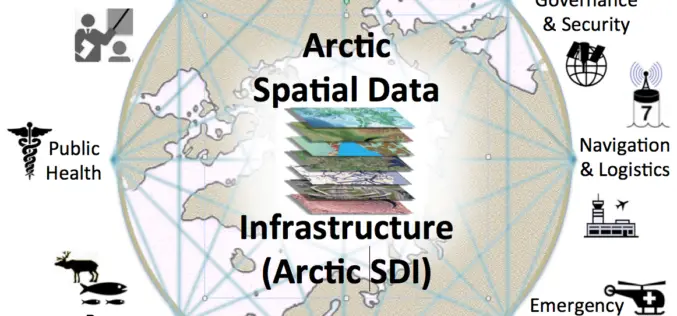
OGC Requests Information to Guide Arctic Spatial Data Pilot
The Open Geospatial Consortium (OGC®) requests information to help advance the “Arctic Spatial Data Pilot”. The Arctic Spatial Data Pilot is an OGC Interoperability Program initiative sponsored by the U.S.
10th International GIS-Forum “Integrated Geospatial Solutions – the Future of Information Technologies”
In 2016 it will be 10th edition of International GIS-Forum “Integrated Geospatial Solutions – the Future of Information Technologies”. We are happy to cordially invite you to participate and celebrate this
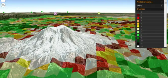
Fire Globe Delivers Esri 3D Visualization to US Firefighters
The National Interagency Fire Center Migrates to the Esri Platform and Improves Situational Awareness Redlands, California—The National Interagency Fire Center (NIFC) has transferred its web GIS application, Fire Globe, to
GeoMesa 1.2: Now with Eclipse LocationTech Vetting!
Release 1.2 of GeoMesa, our open source suite of geospatial analytics tools designed to run with Hadoop-scale volumes of data, is now out. Along with several new features, this is
USGIF Scholarship Program Now Open
The USGIF Scholarship Program and the Ken Miller Scholarship for Advanced Remote Sensing are now open and accepting applications. The USGIF Scholarship Program annually awards doctoral, graduate, undergraduate, and graduating

Training For Thailand Officials at Indian Institute of Surveying & Mapping, Survey of India
The Indian Institute of Surveying & Mapping (IISM), Survey of India, Ministry of Science & Technology, GOI will be inaugurating a training programme for Thailand officials from February 1, 2016.
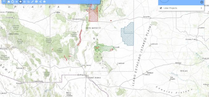
New Mexico Lidar Data Status Map
Increasingly, New Mexico’s key geospatial data needs must be met with high-quality, high-resolution, and current elevation data. Enhanced elevation data are essential to a broad and cross-cutting range of applications,
