
Tag "geospatial"
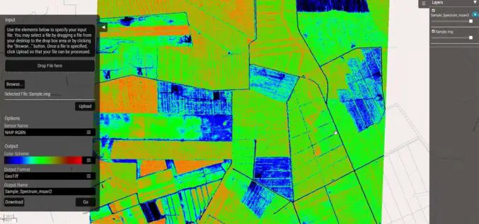
Hexagon Geospatial Launches Vegetation Health Smart M.Apps
Hexagon Smart M.Apps Help Pinpoint Where Crops Need Attention Hexagon Geospatial officially released seven different Vegetation Health Hexagon Smart M.Apps which make use of remote sensing algorithms to identify plant

Bangladesh Govt to Form National Spatial Data Infrastructure (NSDI)
According to recent news, Prime Minister Sheikh Hasina has said her government would soon form ‘National Spatial Data Infrastructure’ (NSDI) to generate geo-data and digital mapping aimed at country’s planned development.

Unleash Agri-Production With Geospatial Technology
Contributed By:- “Food security exists when all people, at all times, have physical, social and economic access to sufficient, safe and nutritious food that meets their dietary needs and food
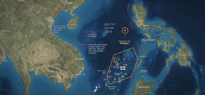
Old Map Denies the Philippines’ Claim Over South China Sea
NEW YORK – An old map published in 1899 by geographer J. Martin Miller shows that islands in the South China Sea have never been Philippine territory, Zeng Yingjing, the
Galileo and EGNOS Benefitting the Geospatial World
Speaking at this week’s Geospatial World Forum in Rotterdam, the European GNSS Agency (GSA) discussed the many benefits that EGNOS and Galileo offer the geospatial sector and, specifically, the surveying

Cameroon’s First Participatory 3D Mapping for Forest Monitoring and Conservation Management
A three-dimensional model of part of the Cameroon Highlands will be unveiled on Monday 30 May in an official ceremony at the Southwest Regional Delegation of Forestry and Wildlife (MINFOF).

Pakistan Express Serious Concern Over India’s Geospatial Bill
According to recent news by The Economics Times, Pakistan has expressed serious concern to the United Nations Security Council (UNSC) over the depiction of Jammu and Kashmir in India’s draft geospatial

Esri Webinar: Effective Vector-Borne Disease Surveillance and Control
Esri Webinar: Effective Vector-Borne Disease Surveillance and Control Thu, May 26, 2016 11:30 PM – Fri, May 27, 2016 12:30 AM IST Show in My Time Zone Understanding the complete
Esri Unveils Advanced Analytics at GEOINT
Demonstrations, Live Training, and Hackathon Winners Show the Power of GIS Redlands, California—Esri, the world leader in geographic information system (GIS) solutions, announced that it will be exhibiting and providing

FAA Expands Drone Detection Pathfinder Initiative
The Federal Aviation Administration (FAA) is expanding the part of its Pathfinder Program that focuses on detecting and identifying unmanned aircraft systems (UAS) flying too close to airports. Today the
