
Tag "remote sensing"

PhD Position: Methodological, Algorithm and Processing Chain Development for Analysis of Hyperspectral Image Data
The institute section “Land Surface” deals with the development of remote sensing methods based on various earth observation systems that are specifically adapted for the respective application scenarios. Key issues
Punjab Government to Utilise Remote Sensing Satellites for Development
Punjab government on Monday said India should make use of its remote sensing satellites more efficiently for development in agriculture and rural and urban planning. “India, having the largest constellation

Insurance Company Using Drones for Crop Yields
According to recent news by the Business Standard, Private insurance companies are using drones to photograph farms and if permitted by the agriculture ministry these could provide data to calculate crop
ISRO to Monitor Water Bodies in Tribal Areas Using Geospatial Technology
New Delhi – In a first, ISRO’s National Remote Sensing Centre (NRSC) will monitor and map the water bodies in tribal belts in the country to help tackle irrigation crisis

Second Belarusian Remote Sensing Satellite in Orbit in 2019
MINSK, 7 April (BelTA) – The Belarusian satellite BKA-2 is supposed to be inserted into an orbit around the Earth in 2019, BelTA learned from Sergei Zolotoi, Chief Designer of
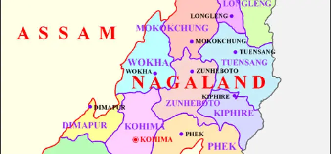
Space Technology Application Necessity in Nagaland
Nagaland’s Parliamentary Secretary Planning & Coordination, Evaluation and Taxes, Neiba Kronu today said that space technology application has become a necessity. The accuracy of all forms of data collected for
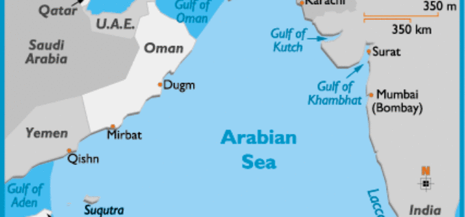
Ocean Acidification Observed in Arabian Sea
The Arabian Sea, cradling a diversity of marine habitats including coral reefs, is witnessing acidification of its surface waters, a consequence of excessive carbon dioxide in the atmosphere, say Indian

ISRO, Indian Railways to Sign MoU Over Remote Sensing and GIS
NEW DELHI: Aiming at effective use of space technology in remote sensing and graphic information system (GIS) based applications, Railways is set to join hands with Indian Space Research Organisation

Iran and APSCO Jointly to Build a Remote Sensing Satellite
According to recent news by the Trend New Agency, Iran and seven member states of the Asia-Pacific Space Cooperation Organization (APSCO) are negotiating to jointly design and build a remote sensing

First Views of Earth From Sentinel-3
ESA– The first image from Sentinel-3A captures the transition from day to night over Svalbard, Norway, with detailed Arctic sea ice and some cloud features. Just after two weeks after
