
Tag "remote sensing"

Research and Markets – Satellite-based Earth Observation Market in Europe 2016-2020
About Satellite-based Earth Observation Market in Europe Satellites transmit data and information in the form of images, which are then collected for analysis. The information thus gathered can be used

Cardno Files U.S. Patent Application for UAS Remote Sensing Process
New patent application filing for Unmanned Aerial Systems UAS remote sensing technology workflow to support abandoned uranium assessment and cleanup. Cardno announced the filing with the U.S. Patent & Trademark Office

PrecisionHawk And DJI Deliver Easy-To-Use Drone And Data Packages For Farmers
The pre-assembled package, which includes DJI’s hardware platform plus PrecisionHawk’s flight and analytics software, is seamlessly integrated to provide a cost-effective and easy remote sensing tool for agriculture PrecisionHawk and

NASA ARSET Training: Using NASA Remote Sensing for Disaster Management
NASA ARSET Training: Using NASA Remote Sensing for Disaster Management 06/09/2016 to 06/30/2016 Times: 11:00 a.m.-12:00 p.m. and 6:00-7:00 p.m. EDT (UTC-4) NASA remote sensing and modeling resources are useful for

Maha Govt Plans to Map Whole State Using Satellite Images
According to recent news by ToI, the Maharashtra state government has planned to develop Maharashtra Geo-Spatial Digital Database System (MGDDS). City-based Maharashtra Remote Sensing Application Centre (MRSAC) has been appointed

Satellite Reveals Decline in the Number of Forest Fires in Uttarakhand
According to recent news by The Hindu, Satellite images show that there’s been a decline in the number of forest fires in Uttarakhand since April 28. Though fires in the
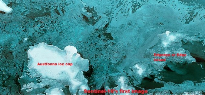
The First Images of Sentinel-1B
Launched on 25 April from Europe’s Spaceport in French Guiana, Sentinel-1B has produced its first images only two hours after the radar was switched on – a record time for

BRICS Nations to Exchange Remote Sensing Data of the Earth
According to recent news by Sputnik News, The BRICS countries are working to implement an initiative of sharing information on the Earth’s remote sensing, which will allow to swiftly respond to emergency situations and disasters, Russia’s
Fundamentals of Satellite Remote Sensing for Health Monitoring
NASA ARSET Training: Fundamentals of Satellite Remote Sensing for Health Monitoring 02 Jun. 2016 to 30 Jun. Times: 10:00-11:30 a.m. and 3:00-4:30 p.m. EDT (UTC-4) Predicting and monitoring disease outbreaks and environmental
Pakistan Inked Contract with China to Develop First Remote Sensing Satellite
According to recent news by The Nation, Pakistan Space & Upper Atmosphere Research Commission (SUPARCO) and China Great Wall Industry Cooperation (CGWIC) signed a contract on Wednesday for the development and
