Vricon Introduces Groundbreaking Medium-resolution Digital Surface Model
November 10, 2015 – Vricon releases a medium-resolution global digital surface model (DSM) for $1.99 per km2 that defines a new industry standard for this product class.
Vricon DSM-10 is produced from commercial satellite imagery, and the product’s accuracy surpasses all medium-resolution global elevation models available today.
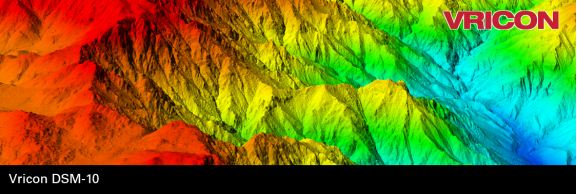
“We are bringing a new product to the market that has a truly disruptive price,” said Magnus Brege, Vricon CEO. “The quality is absolutely superb. We start with The Globe in 3D and then generate 10-meter DSMs. This enables us to offer a DSM with an incredible accuracy of 3 meters LE90. No one else can do this.”
Vricon DSM-10 is innovative on a number of levels. Vricon’s production process begins with a global high-resolution product, guaranteeing unprecedented levels of accuracy and resolution. Vricon is offering its medium-resolution DSM at a price unmatched in the market: $1.99 per km2. Additionally, Vricon has simplified its enterprise license structure, with no charge for additional users.
“It’s a game changer,” said Craig Brower, Vricon vice president. “We have a high-accuracy, globally available elevation product that meets many customers’ requirements, at an extremely affordable price. Vricon DSM-10 fulfills numerous needs, including defense and intelligence, and professional GIS use.”
For more information about Vricon DSM-10, contact info@vricon.com.
About Vricon
Vricon serves the global professional geospatial market with world-leading 3D geodata and 3D visualization solutions. Vricon is headquartered in McLean, Virginia. For further information, visit www.vricon.com.