
Archive
One Stop Shop for Renewable Energy Mapping Data for Australia
The Australian Renewable Energy Agency (ARENA) today announced up to $2.1 million funding for National ICT Australia (NICTA) to develop an online national renewable energy mapping platform. ARENA CEO Ivor
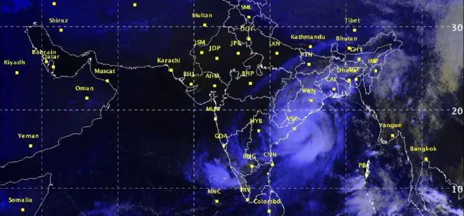
Severe Cyclonic Storm ‘HUDHUD’ over westcentral Bay of Bengal
According to Indian Meteorological Department, the Severe Cyclonic Storm ‘HUDHUD’ over westcentral Bay of Bengal moved northwestwards, intensified into a very severe cyclonic storm and lay centered at 1430 hrs IST

Remote Sensing Data for Managing Climate Risks: Index-based Insurance and Growth related Applications for Smallhold-farmers in Ethiopia
Remote Sensing Data for Managing Climate Risks: Index-based Insurance and Growth related Applications for Smallhold-farmers in Ethiopia Stefan Hochrainer-Stigler, Marijn van der Velde , Steffen Fritz , Georg Pflug Abstract: The aim of
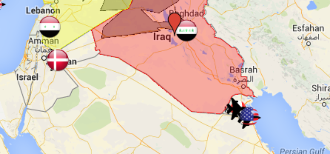
Mapping Air Strike and Air Base locations for the U.S.-led airstrikes on ISIS
According to The Guardian, September 29, 2014, US-led forces launched air strike overnight on territory controlled by Islamic State in Iraq and Syria (ISIS) in northern and eastern Syria while

INCOIS: 3D Mapping of Cyclone Prone Zones
Indian national Centre for Ocean Information Services (INCOIS) has started survey of cyclone prone areas. The survey carried out to build a comprehensive database of all residential and other construction
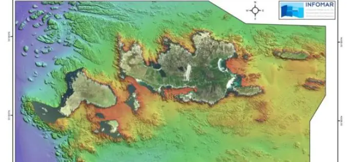
Geological Survey of Ireland Launches ‘Real Map’ of Inishbofin
Marine scientists from the Geological Survey of Ireland (GSI) have created a new offshore map of the island of Inishbofin, County Galway, which will be launched today (11th October 2014)

Latest SuperSurv 3.2 Boosts Convenience of Geospatial Data Collection
Developed by Supergeo, the latest version of SuperSurv (iOS/Android) 3.2 is upgraded with more global coordinates systems functions to bring users a more convenient and intuitive manipulation. SuperSurv, the mobile

SuperSurv Elevates Tequila Industry Development in Mexico
Supergeo Technologies, the global leading GIS software and solution provider, announce that Consejo Regulardor del Tequila (CRT), A. C., Mexico, utilizes SuperSurv to strengthen blue agave management and tequila quality.

Peoples Natural Gas Standardizing Technologies with Esri
Eastern US Utility Streamlines Service with Geospatial Software Redlands, California—Peoples Natural Gas (PNG) is taking steps to further streamline utility service to 700,000 homes and businesses in Pennsylvania, West Virginia,

Topcon Adds Imaging Capability to DS-200 Total Station Series
Topcon Positioning Group announces the addition of imaging capability to its direct aiming line of motorized total stations. The DS-200i provides real-time, touch-screen video and photo imaging to capture measured
