NASA’s Goddard Space Flight Center (GSFC) continues to push the boundaries of Earth observation science with the release of the SatVision Top-of-Atmosphere (TOA) Foundation Model. Developed by the GSFC Data Science Group, this geospatial foundation model is designed for coarse-resolution, all-sky remote sensing imagery, paving the way for significant advancements in atmospheric and Earth system research.
Revolutionizing Remote Sensing Analysis
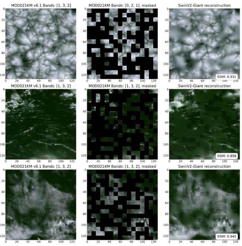
Foundation models like SatVision TOA are transforming how researchers approach remote sensing (RS) data analysis. Unlike traditional models trained only on cloud-free satellite imagery, SatVision TOA incorporates “all-sky” conditions, including clouds and aerosols, into its training process. This innovation allows scientists to tackle challenges in atmospheric science, such as 3D cloud reconstruction and aerosol modelling, without the need for atmospheric corrections.
The model supports pre-training large computer-vision algorithms on extensive RS datasets, reducing the dependency on task-specific models. Fine-tuning these models with smaller labelled datasets opens new possibilities for mapping and monitoring applications across a range of environmental variables.
Also Read – IBM and NASA Launch Prithvi-EO-2.0 for Advanced Geospatial Analytics
A Technological Milestone
SatVision TOA boasts an impressive 3 billion parameters and was trained on a dataset of 100 million images collected from the Moderate Resolution Imaging Spectroradiometer (MODIS). To date, this represents the largest foundation model dedicated solely to satellite RS imagery. The inclusion of diverse cloud conditions, often omitted in traditional training, enhances the model’s versatility, enabling applications like cloud structure analysis and climate monitoring.
This scalability allows SatVision TOA to unify various Earth observation datasets, such as MODIS, VIIRS, and GOES-ABI, and capture global contexts with unparalleled precision. Its robust architecture supports applications ranging from atmospheric science to Earth system modelling, providing researchers with a powerful tool to advance environmental studies.
Accessible and Ready for Application
To ensure accessibility, the SatVision TOA model weights and architecture are available on platforms like GitHub and Hugging Face. The team has also published a comprehensive white paper, SatVision-TOA: A Geospatial Foundation Model for Coarse-Resolution All-Sky Remote Sensing Imagery, offering detailed insights and user guidance.
The model’s development team, including Mark Carroll, Caleb Spradlin, Jordan Caraballo-Vega, Jian Li, Jie Gong, and Paul Montesano, envisions broad applications for SatVision TOA in atmospheric research and beyond. Its adaptability holds promise for unifying Earth observation workflows, reducing task-specific dependencies, and fostering transformative advancements in climate science.
Transforming Earth Observation with NASA’s Expertise
With SatVision TOA, NASA’s Goddard Space Flight Center has set a new benchmark in remote sensing technology. The model not only represents a leap forward in geospatial data analysis but also underscores NASA’s commitment to advancing our understanding of Earth’s systems through cutting-edge innovations.
For researchers, SatVision TOA offers a glimpse into the future of Earth observation—where scalability, adaptability, and precision converge to unlock new insights into our planet’s complex dynamics.
Source: NASA