
Tag "drones"
Drones Against Natural Disasters
In June 2013, the Himalayan state of Uttarakhand experienced severe flooding and landslides, resulting in a catastrophic natural disaster. An Indo-Norwegian cooperation project now provides technical support for mitigating disasters
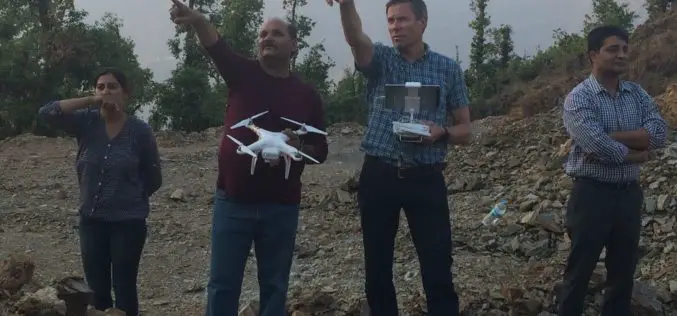
Bengaluru Civic Corporation to Use Drones for Mapping Property & Taxes
India-According to recent news, Bengaluru civic corporation is all set to use unmanned aerial systems (UAS), commonly known as drones, to map urban properties and property taxes. This could help the

FAA Expands Drone Detection Pathfinder Initiative
The Federal Aviation Administration (FAA) is expanding the part of its Pathfinder Program that focuses on detecting and identifying unmanned aircraft systems (UAS) flying too close to airports. Today the
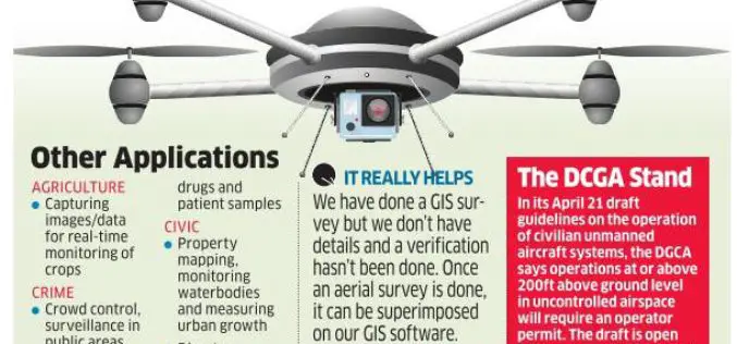
No Proposal with DGCA for Allowing Commercial Use of Drones
There is no proposal at present with aviation regulatorDGCA for allowing commercial use of drones in the country, government said today. The Directorate General of Civil Aviation has recently put

Drones Will Survey Progress for Railway Project
Indian Railways, for the first time, used drones to inspecting a mega rail project and assess the progress on the ground. These drones, unmanned flying machines, will now be used

Insurance Company Using Drones for Crop Yields
According to recent news by the Business Standard, Private insurance companies are using drones to photograph farms and if permitted by the agriculture ministry these could provide data to calculate crop

Esri Webinar: Eyes on the World
Eyes on the World Wed, Apr 20, 2016 | 1:30 AM – 2:30 AM IST Wed, Apr 20, 2016 | 6:30 AM – 7:30 AM IST Drones, UASs, and UAVs
Federal Government Expands UAS Partnerships
The Federal Aviation Administration (FAA) and key government agencies involved in unmanned aircraft operations are expanding participation in the Unmanned Aircraft Systems (UAS) Executive Committee (EXCOM). The committee provides federal

Drones Helping to Conduct High-Resolution Remote Sensing
New York: Earth and environmental scientists are relying on affordable advanced technological drones to conduct long-term high-resolution experiments at a much lower cost than using aircraft or satellites. Unmanned Aerial Vehicles
Drones to Conduct Aerial Surveys of Mines for Coal India
KOLKATA: Coal India is planning to start using drones to conduct aerial surveys of mine blocks that come up for exploration and to assess the extent of greenery restored after
