
Tag "GPS"
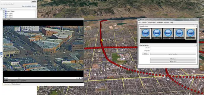
Remote GeoSystems Launches LineVision Google Earth Extension for Project Reporting with Geotagged Videos & Photos
Remote GeoSystems Releases All-New LineVision Google Earth Extension for Geotagged Video Playback, Analysis, Collaboration and Reporting Using Google Earth & Other GIS FORT COLLINS, Colorado – Remote GeoSystems, Inc. is
Trimble Incorporates Galileo Support in New Version of its GNSS Infrastructure Management Software
Delivering Higher-Accuracy Positioning To Improve GNSS Network Performance and Reliability SUNNYVALE, Calif., March 27, 2017—Trimble (NASDAQ: TRMB) introduced today version 3.10 of its Trimble® Pivot™ Platform software, a modular solution
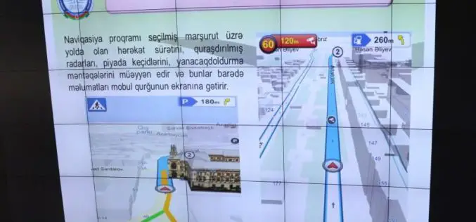
Azerbaijan Launches First National Navigation System – AzNav
According to recent news reported by the AZERNEWS, Azerbaijan has recently launched its first national navigation system “AzNav” by the Center for Information Technology and Information Management of the State Committee on

MapmyIndia Releases eLoc,India’s first Nation-wide Digital Address System
● Simple, precise and ready-to-use for free eLoc,is a unique, 6 character code for any address across India, removing complexity and hassles of providing multi-line, often misspelled addresses and searching

Supergeo Unveils SuperPad 10 Beta
Supergeo Technologies Inc. is excited to announce the beta version of SuperPad 10, its most popular mobile GIS software based on Windows and Windows Mobile OS, has been released at
NovAtel Unleashes Powerful New Positioning Capabilities with the Release of 7.200 Version Firmware
Calgary, Canada, February 2, 2017 – NovAtel’s commitment to precise, ASSURED positioning is central to the launch of our OEM7 7.200 version firmware. Announced today in Calgary, 7.200 firmware introduces
Geotagging of Pipelines for Effective Water Supply Management
Hyderabad-India: According to recent news by The New Indian Express, the Hyderabad Metro Water Supply and Sewerage Board (HMWS&SB) has drawn plans to prepare a reliable and accurate GIS map
DGCA to Airlines: Use GAGAN or Face Consequence
Mumbai – According to recent news by the Mumbai Mirror, the government has warned domestic airlines of `consequences’ if they did not adopt the Rs 774 crore GPS-Aided Geo Augmented

Trimble Changes Name to Reflect Company’s Technology Evolution
Completes Delaware Reincorporation SUNNYVALE, Calif., Oct. 3, 2016 Trimble (NASDAQ: TRMB) announced today that is has formally changed its company name from Trimble Navigation Limited to Trimble Inc. In addition,

TomTom Launches On-Street Parking Service to Help Drivers Find that Parking Spot More Quickly
Paris Motor Show, 29 September 2016 – TomTom (TOM2) today announced the introduction of an On-Street Parking service, a game-changer for drivers on the hunt for that hard to find
