
Tag "LiDAR"

SimActive Provides Integrated LiDAR and Photo Solution to Altoa
SimActive Inc., a world-leading developer of photogrammetry software, is pleased to announce the purchase of its Correlator3D™ software by Altoa from French Guiana. The software will be used to process

Orbit GT and Genesys, India, sign Reseller Agreement
Orbit GT is proud to announce that Genesys, India has been selected as Reseller of Orbit GT Mobile Mapping software products. “We are pleased to have signed a Reseller Agreement
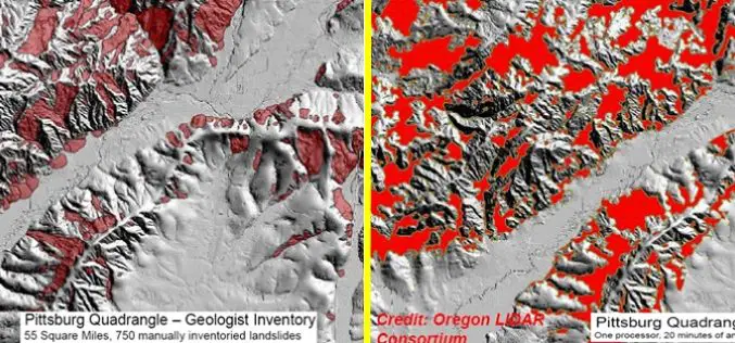
Contour Connection Method: an automated Method for Landslide Identification with LiDAR
In a study by Ben A. Leshchinsky et. al., from Oregon State University has developed a new algorithm “Contour Connection Method” for automated landslide deposits from LiDAR data. Landslide is
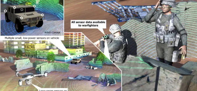
DARPA Develop Technology to Integrate LiDAR on Microchips
DARPA, American defence research agency has developed a LiDAR system small enough to be integrated on a microchip yet offering better performance than conventional bulky mechanical devices. DARPA’s Short-range Wide-field-of-view Extremely agile

Postdoctoral Opportunity in Earth and Environmental Science, Temple University
The Department of Earth and Environmental Science offers students the opportunity to study the Earth with a variety of traditional and environmental geology course work. The faculty work closely with

Updated Global Mapper LiDAR Module Now Supports NIR LiDAR Data
Hallowell, Maine – May 27, 2015 – Blue Marble Geographics (bluemarblegeo.com) is pleased to announce the availability of an upgrade to the Global Mapper LiDAR Module. Released in conjunction with

The 5 Most Viewed UAVs for Mapping and 3D Modelling on Geo-matching.com
The Geo-matching.com website features a selection of the most important geomatics equipment, including UAS for Mapping and 3D Modelling. At www.geo-matching.com you can compare product specifications and read users’ reviews

Global Mapper Version 16.2 Now Available with Improved 3D Viewer, Upgraded Fly-Through Video Playback, and Numerous New Formats
Hallowell, Maine – May 19, 2015 – Blue Marble Geographics (bluemarblegeo.com) is pleased to announce the availability of version 16.2 of Global Mapper. This interim release includes functional upgrades and
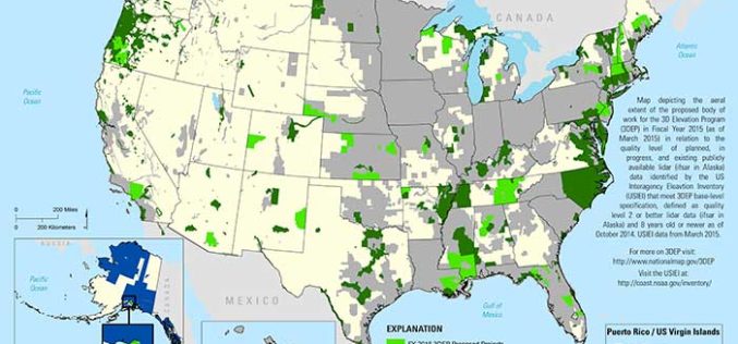
State and Regional 3DEP Stakeholder Workshops Underway
The U.S. Geological Survey National Geospatial Program is developing the 3D Elevation Program (3DEP) to respond to growing needs for high-quality topographic data and for a wide range of other
The 5Most Viewed Airborne Laser Scanners on Geo-matching.com
The Geo-matching.com website features a selection of the most important geomatics equipment, including Airborne Laser Scanners. At www.geo-matching.com you can compare product specifications and read users’ reviews before you buy.
