
Tag "remote sensing"
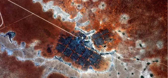
Earth Observation for Humanitarian Aid
Earth observation satellites fly at distances of up to several hundred kilometres from Earth and can provide detailed information that assists relief workers on the ground. Now, this technology will
Iranian Space Agency to Put Indigenous Satellite in Orbit by 2025
According to recent news by MNA – ISA deputy director has announced Iran’s ultimate goal as building indigenous satellites parallel to foreign models and to place them into geosynchronous equatorial
Post-Doctoral Researcher in Grass Crop Remote Sensing and Modelling
The University of Reading is ranked in the top 1% of universities in the world. We are a global university that enjoys a world-class reputation for teaching, research and enterprise.
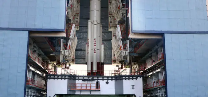
Isro to Launch Cartosat-2 Series Satellite Mission : Scheduled on June 22, 2016
India’s Polar Satellite Launch Vehicle, in its thirty sixth flight (PSLV-C34), will launch the 727.5 kg Cartosat-2 series satellite for earth observation and 19 co-passenger satellites together weighing about 560 kg
Passive and Active Remote Sensing Technology Market Forecast Report – 2015 – 2022
Research Corridor recently added new report titled “Passive and Active Remote Sensing Technology Market – Global Trends, Market Share, Industry Size, Growth, Opportunities, and Market Forecast – 2015 – 2022”

Russia and Italy Agree to Create Remote Sensing Satellite Constellation
MOSCOW (Sputnik) – Russia’s space agency Roscosmos and the Italian Space Agency (ASI) will sign an agreement to create a joint satellite constellation for remote earth sensing later in the day, Roscosmos head

UNITAR: Geospatial Technologies for Flood and Drought Management in East Africa
In the past decade, countries in East Africa have experienced several flood and drought related disasters. These events have led to severe economic and livelihood loss, which in turn greatly

Gaofen-4 – China’s First High Orbit Remote Sensing Satellite Put Into Use
PTI- China’s first high orbit remote sensing satellite, Gaofen-4, said to be the world’s most sophisticated, became operational after six months in-orbit testing, it was announced today. Gaofen-4 is China’s
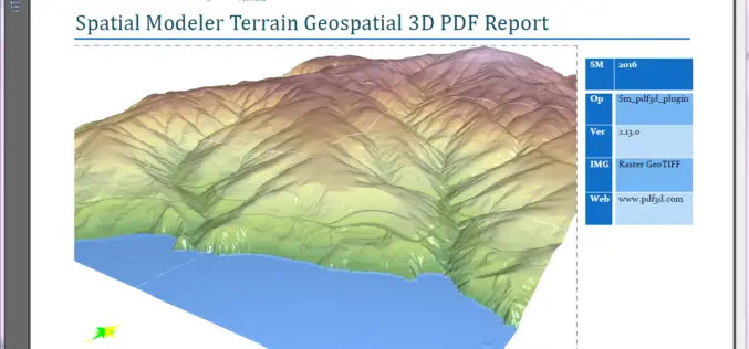
PDF3D Releases 3D Geospatial PDF Plugin for ERDAS IMAGINE at HxGN Live
PDF3D Plugin Released to Create High Quality Geospatial 3D PDF Documents from within ERDAS IMAGINE Spatial Modeler 2016. Anaheim California, June 13th, 2016 – Technological leaders, PDF3D, have today announced

Postdoctoral Researcher in Antarctic Glaciology/Satellite Remote Sensing
The University of Bristol has long been one of the UK’s foremost seats of higher education and a respected institution on the world academic stage. Today, we are widely considered
