
Archive
Copernicus Thematic Workshop With Private Sector Representatives on Raw Materials and the Extractive Industries
Copernicus Thematic Workshop With Private Sector Representatives on Raw Materials and the Extractive Industries Copernicus is a user-driven programme with an important impact on different societal areas involving diverse communities
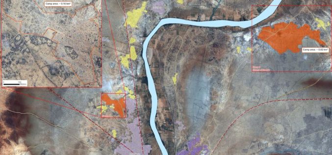
Technologies for Humanitarian Assistance
The German Aerospace Center (Deutsches Zentrum für Luft- und Raumfahrt; DLR) has been actively involved in humanitarian aid for many years. Alongside government partners, the private sector and scientific institutions,

Enhanced Imagery, Modelling, Volumes Improve Productivity With LISTECH Neo
LISTECH, a Hexagon Geosystems brand, today announced increased functionality to its new geospatial software Neo, with terrain modelling, volume calculation and imagery offerings. With an integrated 3D/2D environment for viewing

Create, Share Geotagged, Media-rich Field Reports With New NGA Mobile App
The National Geospatial-Intelligence Agency’s latest publicly available mobile app is now available on iTunes and Google Play. The Mobile Awareness GEOINT Environment, MAGE, was developed to support first responders deploying

PrecisionHawk Launches Reseller Program for Smarter Farming Package
PrecisionHawk, a leading drone and aerial data analytics provider, has formally launched a reseller program for itsSmarter Farming package that rolled out in partnership with drone manufacturer DJI in May.

Topcon Announced All New GT Robotic Series Total Stations
The Ultimate Robotic Total Station The GT Series robotic total station is the fastest, most powerful total station with the smallest and lightest form factor yet. The source of this

Geospatial Tools to Tackle Public Health in Bangladesh
According to recent news published by the University of Texas at Dallas, Geospatial information sciences (GIS) can help determine where diseases are spreading and where to target the resources needed to

GIS Market in BRIC Nations at a CAGR Of 11.13% Between 2016-2020
According to a report published by Technavio, the use of GIS technology in forest fire management, flood management, and carbon management has made the technology an effective tool in disaster management across

IARPA Announces the Multi-View Stereo 3D Mapping Challenge
Washington, D.C. – As reported in a recent press release by the Ofice of the Director of National Intelligence, the Intelligence Advanced Research Projects Activity (IARPA), within the Office of
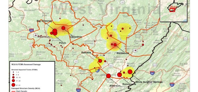
National Geospatial-Intelligence Agency Provides Expertise Response to West Virginia Flooding
As reported in a recent news bulletin by The National Geospatial-Intelligence Agency (NGA), NGA is providing geospatial expertise and damage assessments to the Federal Emergency Management Agency (FEMA) for flooded
