
Posts From GIS Resources

Understanding China’s BeiDou-Only Mandate: Strategic and Global Implications
According to recent news by MSN, China is launching a new campaign to crack down on the theft of sensitive geographical data by foreign powers with its BeiDou-only mandate, the
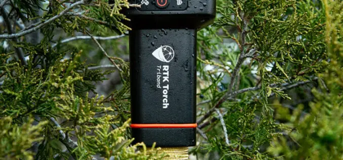
SparkFun Electronics Launch RTK Torch with Millimeter-Level Accuracy
SparkFun Electronics recently launched the RTK Torch, a high-precision GNSS product designed for various geolocation and GIS applications. This new device offers millimeter-level accuracy and is built to withstand tough

Training Announcement – Drought Monitoring, Prediction, and Projection using NASA Earth System Data
The United Nations has documented that drought frequency and duration have increased globally since 2000. According to this report 2.3 billion people around the world are currently facing water stress.
TRISHNA Mission Set to Revolutionize High-Resolution Thermal Imaging
The TRISHNA Mission, a collaborative endeavour between the Indian Space Research Organisation (ISRO) and the French space agency CNES, is set to revolutionize the monitoring of Earth’s surface temperature. TRISHNA

Northeast Frontier Railway (NFR) to Conduct Airborne LiDAR Survey
The Indian Railway’s Northeast Frontier Railway (NFR) zone is set to conduct an Airborne LiDAR Survey on the Lumding to Badarpur hill section. This advanced survey will take place during
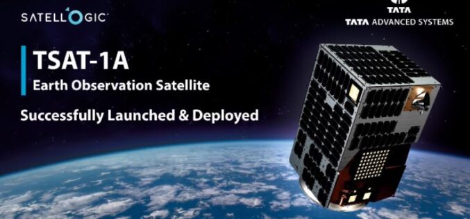
TSAT-1A India’s First Privately-Built Satellite with Sub-Metre Resolution
Developed by Tata Advanced Systems Limited (TASL) in collaboration with Satellogic, TSAT-1A is a state-of-the-art geospatial satellite launched on SpaceX’s Falcon 9 rocket in April 2024. The satellite is designed
Ordnance Survey Expands as a Distributor of Third-party Government Data
Ordnance Survey (OS), Great Britain’s leading geospatial data provider, and BGS, the UK’s leading scientific earth data provider, both Geo6 members, are driving an exciting new development. It is the

Staying Ahead: How Continuous Tech Training Fuels Innovation
Key Takeaways: Upskilling your workforce empowers them to identify areas for improvement and develop solutions, driving a culture of innovation. Strategic planning, resource allocation, and adaptable content address common hurdles

GAF AG Awarded Contract for CAP-Area Monitoring 2024 in Bavaria
As part of an ongoing process of reforms to modernise and simplify the EU’s CAP, since January 2023 the monitoring of subsidy payments has been carried out on the basis

Descartes Labs Government Accelerates Mission-Ready Solutions with EarthDaily Constellation Earth Observation Data
Descartes Labs and its subsidiary, Descartes Labs Government, has selected EarthDaily Analytics as a supplier for their Earth observation data to power their geospatial analytics and AI solutions. EarthDaily’s Constellation will unlock
